a. Invited papers and posters since 2000
March
2000 - Bloomington, IN
Indiana University Department of Computer
Science Horizon
Day
Lecture
Linking
Computers to Solve Environmental Problems: Optimistic Clairvoyance
from an Applied Perspective.
(invited).
October
2000 – Oak Ridge, TN
Friends of ORNL
From Aesop’s Fable
to Beowulf: the (Soon-to-Be) Legend of the Stone SouperComputer.
(invited)
October
2000 – Knoxville, TN
American Meteorological Society, Smoky
Mountains Chapter
The Stone SouperComputer Project at ORNL.
(invited)
March
2001 – Winston-Salem, NC
2001 North Carolina Geographic
Information Systems Conference (NCGIS) 2001: A Spatial
Odyssey
Pushing the Envelope: Multivariate Spatio-Temporal
Clustering (MSTC) using a Parallel Supercomputer. (invited)
August
2001 – Oak Ridge, TN
ORNL Physics Division Colloquium
The
Stone SouperComputer: a Beowulf-style Cluster for Tackling
Ecological Computational Problems. (invited)
April
2002 – St. Petersburg, FL
Atmospheric Radiation Measurement
(ARM) Science Team Meeting
A “Make-a-difference” Experiment
to Assess the Value of ARM Data in Carbon Cycle Models. (invited)
May
2002 – Nashville, TN
Nashville Linux Users Group
The Stone
SouperComputer: a Beowulf-style Cluster for Tackling Ecological
Computational Problems. (invited)
June
2002 – Breckenridge, CO
Community Climate System Model (CCSM)
Annual Meeting, Climate Change and Assessment Working Group
Animations
and Early Clustering Results using PCM Model Output.
(invited)
June
2002 – Knoxville, TN
C. Warren Neel Conference on the New
Frontiers of Statistical Data Mining and Knowledge Discovery
Data
Mining with Multivariate Spatio-Temporal Clustering.
(invited)
July
2002 – Beltsville, MD
USDA Agricultural Research Service
Germplasm Research Information Network
Computer-generated
Ecoregions as a Basis for Sampling-network Design. (invited)
August
2002 – Peoria, IL
Insurance Industry Risk and Catastrophe
Modeling Workshop
EMBYR, a Probabilistic Model of Wildfire
Propagation Risk. (invited)
August
2002 – Cookeville, TN
U.S. Fish and Wildlife Service Regional
GIS workshop, Management track
Computer-generated Ecoregions as
a Basis for Sampling-network Design. (invited)
August
2002 .– Oak Ridge, TN
FishHeads Friday, ORNL Environmental
Sciences Division
Animations
and Early Clustering Results Using PCM Model Output.
(invited)
September
2002 – Germantown, MD
U.S. Department of Energy (DOE), Office
of Biological and Environmental Research Seminar
Using
Clustering to Establish Climate Regimes from a Global Climate Model.
(invited)
September
2002 – Knoxville, TN
Southern Appalachian Information Node,
NBII
A Map-Analysis Tool for Corridor Detection. (invited)
March
2003 – Broomfield, CO
Atmospheric Radiation Measurement (ARM)
Science Team Meeting
Characterizing
and Filling Temporal Gaps in Hour-Aggregated ARM Measurements for
Use in Carbon Models. (invited)
March
2003 – Broomfield, CO
Atmospheric Radiation Measurement (ARM)
Science Team Meeting
Multivariate
Spatio-Temporal Clustering of Time-Series Data: an Approach for
Diagnosing Cloud Processes and Understanding ARM Site
Representativeness.
(invited)
June
2003 – Breckenridge, CO
Community Climate System Model (CCSM)
Annual Meeting
Using
Multivariate Spatio-Temporal Clustering to Establish Climate Regimes
from Parallel Climate Model (PCM) Results.
(invited)
July
2003 – Knoxville, TN
East Tennessee Computer Society (ETCS)
Meeting
The
Stone SouperComputer: Applying a Heterogeneous Beowulf-Style Cluster
to Ecological Multivariate Clustering.
(invited)
July
2003 – Maui, HI
NBII Biodiversity Modeling Meeting
Statistical
Location of Hutchinsonian Environmental Niche Hypervolumes using
Fixed-Radius Multivariate Geographic Clustering. (invited)
November
2003 – Boulder, CO
AmeriFlux
Science Team Meeting and Department of Energy (DOE) Terrestrial
Carbon Processes Annual Meeting
Using
Representativeness to Guide Expansion of the AmeriFlux
Network.
(invited)
August
2004 – Knoxville, TN
University of Tennessee, Knoxville
Innovative Computing Laboratory (ICL) Colloquium
Why
Linux Clusters are Good for the Environment.
(invited).
September
2004 –
Shepherdstown, WV
Society
for Conservation GIS – National Conservation Training Center,
WV
Panel Discussion – Evaluation of Conservation Strategies and
Systems
(invited).
September
2004 – Champaign, IL
CERL Army Corps of Engineers
Using a
Corridor Tool to Define Threatened and Endangered Species for Areas
near Military Bases
(invited).
March
2005 – Daytona Beach, FL
15th
Atmospheric Radiation Measurement (ARM) Science Team
Meeting
Multivariate
Spatio-Temporal Clustering of Time Series Data: An Approach for
Diagnosing Cloud Properties and Understanding ARM Site
Representativeness.
(invited)
April
2005 – Knoxville, TN
University of Tennessee Environmental
Semester
A Practical Map-analysis Tool for Potential Corridor
Detection
(invited).
September
2005 – Berkeley, CA
Lawrence Berkeley National Laboratory
(LBNL) Scientific Computing Seminar
Climate
and Carbon Software Engineering and Research on High End Computers.
(invited)
November
2005 – Asheville, NC
P.
ramorum
(Sudden Oak Death) Modelers’ Meeting
Predicting
National Susceptibility Patterns for Sudden Oak Death.
(invited)
May
2006 – Washington, DC
Invited Meeting with Daniel M. Ashe,
Director, US Fish & Wildlife Service
Multivariate
Network Analysis Capabilities of Potential Interest to the US Fish &
Wildlife Service
(invited)
May
2006 – Washington, DC
Invited Meeting with Roger C. Dahlman,
Director, US DOE Office of Science, Biological and Environmental
Research
AmeriFlux
Representativeness, Site Importance, and Network Design.
(invited)
February
2006 – Boulder, CO
North American Carbon Program (NACP)
Mid-Continent Intensive Task Force Meeting
Updated
Flux-Relevant Ecoregionalization Analysis for the NACP Mid-Continent
Intensive.
(invited)
March
2006 – San Diego, CA
21st Annual U.S. International Association
of Landscape Ecology Meeting
Development of a Domain Map for
Nodes of the National Ecological Observatory Network (NEON).
(invited)
March
2006 – San Diego, CA
21st Annual U.S. International Association
of Landscape Ecology Meeting
MapCurves: A Quantitative Method
for Comparing Categorical Maps. (invited)
March
2006 – San Diego, CA
21st Annual U.S. International Association
of Landscape Ecology Meeting
Using
Clustered Climate Regimes for Understanding General Circulation
Model Results.
(invited)
March
2006 – San Diego, CA
21st Annual U.S. International Association
of Landscape Ecology Meeting
Use of Multivariate Cluster and
Climate Classification Techniques to Characterize Future Climate
Scenarios in the People’s Republic of China. (invited)
March
2006 – San Diego, CA
21st Annual U.S. International Association
of Landscape Ecology Meeting
Applying
Quantitative Ecoregionalization to Network Analysis: Quantifying
Representativeness and Determining Importance Values for AmeriFlux
Sites.
(invited)
March
2006 – Albuquerque, NM
16th
Atmospheric Radiation Measurement (ARM) Science Team Meeting
From
Measurements to Models: Cross-Comparison of Measured and Simulated
States of the Atmosphere.
(invited)
September
2006 – Boone, NC
Appalachian State University
Multivariate
Geographic Clustering as a Basis for Ecoregionalization in the
Environmental Sciences
(invited).
October
2006 - Boulder, CO
AmeriFlux
Science Team Meeting
Constituency:
Mapping the Areas that Flux Towers Represent Best.
(invited)
October
2006 – Chicago, IL
American Statistical Association
Plenary:
The Potential of Multivariate Quantitative Methods for Delineation
and Visualization of Ecoregions
(invited).
November
2006 - Salt Lake City, UT
USDA FS Remote Sensing Applications
Center (RSAC) Forest Disturbance Mapping Meeting
Conceptual
Design for an Early Warning System
(invited).
November
2006 - Tampa, FL
SuperComputing 2006 (SC06)
Development
of a Domain Map for Nodes of the NSF's National Ecological
Observatory Network (NEON)
(invited)
December
2006 - San Francisco, CA
American Geophysical Union (AGU) Fall
Meeting
Multivariate
Geographic Clustering as a Basis for Ecoregionalization in the
Environmental Sciences
(invited).
January
2007 - Colorado Springs, CO
North American Carbon Program (NACP)
Investigators Meeting
Constituency:
Mapping the Areas that Flux Towers Represent Best
(invited)
January
2007 - Colorado Springs, CO
Joint Canada-Mexico-USA Carbon
Program Planning Meeting
Representativeness
Mapping of FluxNet Tower Sites
(invited)
March
2007 - Monterey, CA
17th Atmospheric Radiation Measurement (ARM)
Science Team Meeting
From
Measurements to Models: Cross-Comparison of Measured and Simulated
Behavioral States of the Atmosphere
(invited)
April
2007 - Tucson, AZ
22nd Annual Symposium of the International
Association for Landscape Ecology (US-IALE)
Calculating
Dispersal Pathways from Yellowstone to the Yukon and within the
Southeastern Ecological Framework using the PATH Tool
(invited)
April
2007 - Tucson, AZ
22nd Annual Symposium of the International
Association for Landscape Ecology (US-IALE)
Using
the PATH Model to Predict Corridors for Red-Cockaded Woodpecker and
Gopher Tortoise Near Military Installations
(invited)
April
2007 - Stennis, MS
Stennis Space Center Review Meeting
A
Prototype Forest Threat Detection System Using Statistically Defined
Forest States.
(invited)
September
2007 - Asheville, NC
Stennis Space Center Review
A
Prototype Threat Detection System Using Statistically Defined Forest
States.
(invited)
September
2007 - Pawley's Island, SC
WWETAC/EFETAC Retreat
A
Prototype Threat Detection System Using Statistically Defined Forest
States.
(invited)
January
2008 – Portland, OR
Western Wildland Environmental Threat
Assessment Center (WWETAC) Climate Change Modeling Workshop
No
formal presentation (invited).
February
2008 – San Antonio, TX
Forest Health Monitoring 14th Annual
Meeting
Tree Species Range Shifts Following Climate Change
(invited).
April
2008 – Madison, WI
23rd Annual Symposium of the International
Association for Landscape Ecology (US-IALE)
Assessing
MODIS-based Products and Techniques for Detecting Gypsy Moth
Defoliation (invited).
April
2008 – Madison, WI
23rd Annual Symposium of the International
Association for Landscape Ecology (US-IALE)
Development
of the FIRST National Early Warning System for Forest Threats
(invited).
May
2008 – Portland, OR
National Environmental Threat Assessment
Mapping (NETAM) Workshop
Development of the FIRST National Early
Warning System for Forest Threats (invited).
August
2008 – Chattanooga, TN
51st Annual Southern Forest Insect Work
Conference (SFIWC)
Quantitative
Regionalization as a Basis for Long-Term National Monitoring of
Forest Threats
(invited)
January
2009 – Asheville, NC
North Carolina Federal Interagency
Committee Meeting
Quantitative
Regionalization as a Basis for Long-Term National Monitoring of
Forest Threats
(invited)
March
2009 – Athens, GA
Forest Service Center for Forest Disturbance
Science, Athens GA Unit
Quantitative
Regionalization as a Basis for Long-Term National Monitoring of
Forest Threats
(invited)
March
2009 – Oak Ridge, TN
ORNL Environmental Sciences Division
Research Seminar
Quantitative
Regionalization as a Basis for Long-Term National Monitoring of
Forest Threats
(invited)
March
2009 – Asheville, NC
Blue Ridge Sustainability Institute –
Leadership Team
Quantitative
Regionalization as a Basis for Long-Term National Monitoring of
Forest Threats
(invited)
May
2009 – Stennis, MS
NASA Applied Sciences Program Research
Seminar
Derived
Phenology Products Calculated From MODIS Phenology Parameters
(invited)
June
2009 – London, United Kingdom
IEEE Seminar
Multivariate
Spatio-Temporal Clustering (MSTC) as a Data Mining Tool for
Environmental Applications.
(invited)
July
2009 – Oak Ridge, TN
Center for BioEnergy Sustainability
Forum
Optimizing Global Placement of Biofuels Crops and Their
Effect on Climatic Change (invited)
July
2009 – Atlanta, GA
Eastern Forest Environmental Threat
Assessment Center Threat Advisory Committee (TAC) Review
Long-Term
National Monitoring of Forest Threats
(invited)
August
2009 – Pescadero, CA
Pest Risk Mapping Workshop
Quantitative
Regionalization as a Basis for Pest Risk Mapping
(invited)
August
2009 – Pescadero, CA
International Pest Risk Mapping Workgroup
(IPMRW)A
Practical Map Analysis Tool for Detecting Potential Dispersal
Corridors
(invited)
September
2009 – Orlando, FL
Society of American Foresters Annual
Meeting
Landscape-Scale
Approaches to Forest Change
(invited)
September
2009 – Salt Lake City, UT
Remote Sensing Applications Center
(RSAC) Trends in Land Cover Change Workshop
Toward
a National Early Warning System for Forest Disturbances Using
Remotely Sensed Land Surface Phenology
(invited)
October
2009 – Asheville, NC
Lecture, University of North Carolina
Asheville
Landscape-Scale
Approaches to Forest Change Detection
(invited)
October
2009 – Asheville, NC
Blue Ridge Sustainability Institute (BRSI)
Green
Mondays Seminar Series
Multivariate
Sustainability Comparison Scores.
(invited)
October
2009 – Milwaukee, WI
USA - National Phenology Network (USA-NPN)
Research Coordination Network (RCN) Meeting
No formal
presentation (invited).
January
2010 – Albuquerque, NM
2010 Forest Health Monitoring Workgroup
Meeting
Working
Toward a National Early Warning System for Forest Disturbances with
Help from the ADS Program.
(invited)
January
2010 – Albuquerque, NM
2010 Forest Health Monitoring Workgroup
Meeting
Assessing
Forest Tree Risk of Genetic Degradation from Climate Change
(invited)
February
2010 – Asheville, NC (webinar)
EFETAC/WWETAC Research
Seminar
Working
Toward A National Early Warning System for Forest Disturbances With
Help from the ADS Program
(invited)
March
2010 – Corvallis, OR
USDA Forest Service Forest Genetic
Research Management Climate Change Workshop
A Spatially Explicit
Assessment of Climate Change Genetic Risk to 200 Forest Tree
Species. (invited)
March
2010 – Stoneville, MS
57th
Annual Southern Hardwood Forest Research Group Meeting
Do
Southern Hardwood Forests Have a Future? (invited)
April
2010 – Missoula, MT
Cohesive Fire Strategy Research
Meeting
Statistically
Delineating Two Independent Sets of Wildfire Biophysical Regions for
the Conterminous United States
(invited)
April
2010 – Athens, GA
25th Annual Symposium of the International
Association for Landscape Ecology (US-IALE)
Land Cover-Based
Phenology Derived from MODIS Time Series. (invited)
April
2010 – Athens, GA
25th Annual Symposium of the International
Association for Landscape Ecology (US-IALE)
Use of Multi-year
MODIS Phenological Data Products to Detect and Monitor Forest
Disturbances at Regional and National Scales. (invited)
April
2010 – Athens, GA
25th Annual Symposium of the International
Association for Landscape Ecology (US-IALE)
High-Resolution
National Phenological Ecoregions and Their Utility for Forest
Monitoring
(invited)
June
2010 – Raleigh, NC
North Carolina Climate Change Coordination
Meeting
Climate Change, Forest Trees and Genetic Peril: Range
Modeling for North Carolina and Beyond. (invited)
July
2010 – Honolulu, HI
International Geoscience and Remote Sensing
Symposium (IGARSS) 2010
Geospatiotemporal
Data Mining in an Early Warning System for Forest Threats in the
United States.
(invited)
July
2010 – Raleigh, NC
Presentation to USDA Forest Service
Washington Office Policy Analysis Interns
Climate Change, Forest
Trees and Genetic Peril. (invited)
August
2010 – Seoul, South Korea
XXIII International Union of Forest
Research Organizations (IUFRO) World Congress
Predicting
Future Threats to Forests Using Environmental Variables
(invited)
August
2010 – Asheville, NC
5th
Symposium on Hemlock Wooly Adelgid
Of Microsatellites, HWA and
Climate Change: Assessing Genetic Diversity, and Threats to It,
Across the Range of Eastern Hemlock. (invited)
September
2010 – Milwaukee, WI
National Phenological Network (US-NPN)
Research Coordination Network (RCN) Federal Stakeholders Meeting
No
formal presentation. (invited)
November
2010 – Research Triangle Park, NC
Presentation to Duke
University MS of Env. Mgmt. and MS of Forestry Students
Climate
Change, Forest Trees and Genetic Peril. (invited)
November
2010 – Gatlinburg, TN
Southern Appalachians Man and the
Biosphere (SAMAB)
Toward
a National Early Warning System for Forest Disturbances Using
Remotely Sensed Land Surface Phenology
(invited)
November
2010 – Gatlinburg, TN
Southern Appalachians Man and the
Biosphere (SAMAB)
Of
Microsatellites, HWA, and Climate Change: Assessing Eastern Hemlock
Genetic Diversity, and Threats to It, in the Southern Appalachians.
(invited)
November
2010 – Gatlinburg, TN
Southern Appalachians Man and the
Biosphere (SAMAB)
Modeling
the Timing and Duration of the Appalachian Spring: Implications for
Biodiversity and Wildfire. (invited)
December
2010 – Denver, CO
Remote Sensing Applications Center
(RSAC)/Forest Health Technology Enterprise Team (FHTET) Combined
Planning Meeting
Toward
a National Early Warning System for Forest Disturbances Using
Remotely Sensed Land Surface Phenology.
(invited)
December
2010 – Asheville, NC (webinar)
First Friday All Climate Change
Talks (FFACCTS,
Northern- and Southern Station-wide Web Seminar)
Global
Tree Range Shifts Under Forecasts from Two Alternative GCMs Using
Two Future Scenarios.
(invited)
February
2011 – Prineville, OR
Western Wildlands Environmental Threat
Assessment Center (WWETAC) EWS Planning Meeting
Toward
a National Early Warning System for Forest Disturbances Using
Remotely Sensed Land-Surface Phenology.
(invited)
February
2011 – Asheville, NC
National Climatic Data Center (NCDC)
Thirsty Thursday Environmental Science Seminars
Keynote Initial
Presentation: Toward
a National Early Warning System for Forest Disturbances Using
Remotely Sensed Land-Surface Phenology.
(invited)
February
2011 – Champaign-Urbana, IL
University of Illinois, Department
of Natural Resources and Environmental Sciences
Forecasting
Ecosystem Shifts in Response to Climate Change..
(invited)
February
2011 – Washington, DC
National Aeronautics and Space
Administration (NASA) Inter-Agency
Forum on Climate Change Impacts & Adaptations
U.S.
Scenarios for Ecosystem Stressors from Global Change. (invited)
March
2011 – Asheville, NC (webinar)
First Friday All Climate Change
Talks (FFACCTS,
Northern- and Southern Station-wide Web Seminar)
A
Framework for Assessing the Relative Risk of Genetic Degradation to
Forest Trees Affected by Climate Change and Other Threats.
(invited)
March
2011 – Asheville, NC (webinar)
Threat Assessment Centers
Technical Users Group (TUG) Initial Meeting
A
Prototype National Early Warning System for Forest Disturbances
Based on Remotely Sensed Land Surface Phenology.
(invited)
March
2011 – Asheville, NC (webinar)
Threat Assessment Centers
Technical Users Group (TUG) Initial Meeting
Global
Tree Range Shifts Under Forecasts from Two Alternative GCMs Using
Two Future Scenarios.
(invited)
March
2011 – Asheville, NC (webinar)
Threat Assessment Unit-Wide
Meeting
A
Cross-Scale Approach for Modeling Species Local Response To Climate
Change.
(invited)
April
2011 – Asheville, NC (webinar)
USDA Forest Service, Southern
Research Station (SRS)
Geospatiotemporal
Data Mining Applications in Forest Ecology.
(invited)
April
2011 – Asheville, NC
U.S. Department of Energy (DOE) Computer
Graphics Forum
Determining Shifts in Climate Regimes Using Earth
System Model Projections. (presentation
video on Climate Change Resources site)
(invited)
April
2011 – Portland, OR
26th Annual Symposium of the International
Association for Landscape Ecology (US-IALE)
Integrating
Phenology into Cross-Scale Risk Assessments of Climate Change.
(presentation
video on Climate Change Resources site)
(invited)
April
2011 – Portland, OR
26th Annual Symposium of the International
Association for Landscape Ecology (US-IALE)
Potential of MODIS
satellite Data for Assessing Forests Vulnerable to Climate Change
Impacts, Based on a Northern Front Range Case Study. (invited)
April
2011 – Portland, OR
26th Annual Symposium of the International
Association for Landscape Ecology (US-IALE)
Determining
Shifts in Climate Regimes Using Earth System Model Projections.
(invited)
April
2011 – Portland, OR
26th Annual Symposium of the International
Association for Landscape Ecology (US-IALE)
Global
Tree Range Shifts Under Forecasts from Two Alternative GCMs Using
Two Future Scenarios.
(presentation
video on Climate Change Resources site)
(invited)
April
2011 – Portland, OR
26th Annual Symposium of the International
Association for Landscape Ecology (US-IALE)
Anticipating
Climate-Change Induced Biome Shifts for Military Reservations.
(presentation
video on Climate Change Resources site)
(invited)
April
2011 – Portland, OR
26th Annual Symposium of the International
Association for Landscape Ecology (US-IALE)
Adapt, Move, or Die:
Spatially Explicit Assessment of Climate Change Genetic Degradation
Risk in Forest Trees. (invited)
May
2011 – Lafayette, LA
United States Geological Survey (USGS)
National Wetlands Research Center (NWRC)
Use
of MODIS Forest Monitoring Products in Developing a Forest Threat
Early Warning System.
(invited)
May
2011 – Knoxville, TN
Forest Inventory Analysis (FIA) Office,
Region 8
Global
Tree Range Shifts Under Forecasts from Two Alternative GCMs Using
Two Future Scenarios using FIA.
(invited)
June
2011 – Roanoke, VA
North American Forest Ecology Workshop
(NAFEW)
Adapt, Move or Die: Assessments of Forest Tree Genetic
Degradation Risk due to Climate Change. (invited)
June
2011 – Republic of Singapore
International Conference on
Computational Science 2011 (ICCS 2011), Data Mining in Earth System
Science (DMESS 2011)
Keynote Address: Data
Mining in Earth System Science.
(invited)
June
2011 – Republic of Singapore
International Conference on
Computational Science 2011 (ICCS 2011), Data Mining in Earth System
Science (DMESS 2011)
Parallel
k-Means Clustering for Quantitative Ecoregion Delineation Using
Large Data Sets.
(invited)
June
2011 – Republic of Singapore
International Conference on
Computational Science 2011 (ICCS 2011), Data Mining in Earth System
Science (DMESS 2011)
Cluster
Analysis-Based Approaches for GeoSpatioTemporal Data Mining of
Massive Data Sets for Identification of Forest Threats.
(invited)
July
2011 – Asheville, NC (webinar)
USDA Forest Service
“Conversations with the Chief”
A
New National Early Warning System for Forest Disturbances Using
Remotely Sensed Land Surface Phenology.
(invited by Chief Tidwell)
July
2011 – Asheville, NC (webinar)
U.S. Fish & Wildlife
Northeast Region Science
in Action Seminar Series
Global
Tree Range Shifts Under Forecasts from Two Alternative GCMs Using
Two Future Scenarios.
(invited)
August
2011 – Minneapolis, MN
First Workshop on Understanding Climate
Change through Data
Data
Mining for Climate Change Model Intercomparison
(invited)
August
2011 – Austin, TX
96th Ecological Society of America Annual
Meeting
Forest
Tree Species Range Shifts Under Two Alternative GCM/Scenario Climate
Change Forecasts.
(invited)
August
2011 – Austin, TX
96th
Ecological Society of America Annual Meeting
Toward Gene
Conservation Triage: Assessing the Relative Genetic Risk to Forest
Trees Affected by Multiple Threats. (invited)
September
2011 – Madrid, Spain
IUFRO Restoring Forests: Advances in
Techniques and Theory
Determining Suitable Locations for Seed
Transfer under Climate Change: A Global Quantitative Method.
(invited)
December
2011 – San Francisco, CA
American Geophysical Union (AGU) Fall
Meeting
Using
Land Surface Phenology as the Basis for a National Early Warning
System for Forest Disturbances.
(invited)
January
2012 – Oak Ridge, TN
Climate Change Science Institute (CCSI)
Scientific Advisory Board Meeting
Site
Representativeness and Sampling Network Design for the Next
Generation Ecosystem Experiment (NGEE)-Arctic.
(invited)
January
2012 – Oak Ridge, TN
Climate Change Science Institute (CCSI)
Scientific Advisory Board Meeting
A
Statistical Methodology for Detecting and Monitoring Change in
Forest Ecosystems Using Remotely Sensed Imagery.
(invited)
February
2012 – Knoxville, TN
National Institute for Mathematical and
Biological Synthesis (NIMBioS Workshop on Disturbance Regimes and
Climate-Carbon Feedbacks
A
Statistical Methodology for Detecting and Monitoring Change in
Forest Ecosystems Using Remotely Sensed Imagery.
(invited)
March
2012 – Asheville, NC (web interview)
Capital Ideas Live!
Alabama Forest Owners’ Association, Inc.
ForWarn:
A Satellite-Based Monitoring and Assessment Tool.
(audio)
(invited)
March
2012 – Minneapolis, MN
Department of Computer Science and
Engineering, University of Minnesota
ForWarn:
A New Satellite-Based Change Recognition and Tracking System for
Identification of Forest Disturbances.
(invited)
March
2012 – Oswego, MN
Climate Adaptation in the Northwoods
Forest
Tree Species Range Shifts Under Two Alternative GCM/Scenario Climate
Change Forecasts.
(invited)
March
2012 – Asheville, NC (webinar)
Initial ForWarn
Unveiling and Rollout Webinar
ForWarn:
A New Satellite-Based Change Recognition and Tracking System for
Identification of Forest Disturbances.
(video)
(invited)
March
2012 – Asheville, NC (webinar)
Second ForWarn
Unveiling and Rollout Webinar
Using the ForWarn
Change Assessment Viewer and Performing Forest Disturbance
Assessments. (video)
(invited)
March
2012 – Miami, FL
10th Annual Climate Prediction Applications
Science Workshop
Forecasting
Global Ecosystem Change Pressure.
(invited)
April
2012 – Asheville, NC (webinar)
North Carolina Forest Service
Forest Monitoring Planning Meeting
ForWarn:
A New Satellite-Based Change Recognition and Tracking System for
Identification of Forest Disturbances.
(invited)
April
2012 – Asheville, NC (webinar)
U.S. Fish & Wildlife
Service Remote Sensing Task Group
ForWarn:
A New Satellite-Based Change Recognition and Tracking System for
Identification of Forest Disturbances.
(invited)
April
2012 – Boone, NC
Biology Department Seminar, Appalachian State
University
Understanding
Vegetation Change for Coarse-Filter Management.
(invited)
April
2012 – Tucson, AZ
2012 Forest Health Monitoring Work Group
Meeting
Where
are the Margins that We Should Monitor? Dark (and Bright!) Corners
of the Environmental Envelope.
(invited)
May
2012 – Milwaukee, WI
USA National Phenology Network (USA-NPN)
Research Coordination Network (RCN) Meeting
No
formal presentation (invited).
July
2012 – Asheville, NC (webinar)
Forestry
& Natural Resources Webinar,
Southern Regional Extension Forestry
ForWarn:
A New Satellite-Based Change Recognition and Tracking System for
Identification of Forest Disturbances. (invited).
August
2012 – Asheville, NC (webinar)
USDA Forest Service Southern
Station Station Management Review
ForWarn
Forest Disturbance Change Detection System Provides a Weekly
Snapshot of US Forest Conditions to Aid Forest Managers
(invited).
August
2012 – Sioux Falls, SD
USGS Earth Resources Observation and
Science (EROS) Data Center
ForWarn:
A New Satellite-Based Change Recognition and Tracking System for
Identification of Forest Disturbances
(invited).
August
2012 – Morgantown, WV
Appalachian Mountains Joint Venture
Technical Committee Meeting
The
Eastern Forest Environmental Threat Assessment Center
(invited).
August
2012 – Brookings, SD
Geographic Information Science Center of
Excellence, South Dakota State University
ForWarn:
A New Satellite-Based Change Recognition and Tracking System for
Identification of Forest Disturbances
(invited).
September
2012 - Knoxville, TN
Forest Inventory and Analysis (FIA) Meeting
with USGS
Using
Land Surface Phenology for National Mapping of the Occurrence and
Health of Evergreen and Deciduous Forests
(invited)
October
2012 - Asheville, NC (virtual)
USDA Forest Service Climate Change
Field Team Meeting
Monitoring
and Predicting Effects of Climate Change on Forests
(invited)
November
2012 - Asheville, NC
NASA LCC-VP Project Meeting - Blue Ridge
National Park Headquarters
Forest
Tree Species Range Shifts Under Two Alternative GCM/Scenario Climate
Change Forecasts
(invited)
December
2012 - San Francisco, CA
American Geophysical Union (AGU) Fall
Meeting
ForWarn:
A Cross-Cutting Forest Resource Management and Decision Support
System Providing the Capacity to Identify and Track Forest
Disturbances Nationally
(invited)
December
2012 - San Francisco, CA
American Geophysical Union (AGU) Fall
Meeting
ForWarn
Forest Change Detection System Provides a Weekly Snapshot of US
Forest Conditions to Aid Forest Managers
(invited)
January
2013 - Asheville, NC
EFETAC-NPS Meeting at Forest Service
Southern Research Station
ForWarn
Forest Change Detection System Provides a Weekly Snapshot of US
Forest Conditions to Aid Forest Managers.
(invited)
January
2013 - Asheville, NC
EFETAC-NPS Meeting at Forest Service
Southern Research Station
The
Land Surface Phenology of Great Smoky Mountains National Park: A
Preliminary Satellite and Climatic Analysis
(invited)
February
2013 - Little Rock, AR
Southern Group of State Foresters (SGSF)
GIS Task Force Annual Meeting
ForWarn
Forest Change Detection System Provides a Weekly Snapshot of U.S.
Forest Conditions to Aid Forest Managers (invited)
March
2013 - Gatlinburg, TN
Great Smoky Mountains National Park Science
Colloquium
ForWarn
Forest Change Detection System Provides a Weekly Snapshot of U.S.
Forest Conditions to Aid Forest Managers
(invited)
March
2013 - Gatlinburg, TN
National Park Service, Appalachian
Highlands Network
Forest Disturbance Mapping and Phenology
Research (invited)
April
2013 - Opelika, AL
Alabama Forest Owners Association
ForWarn
Forest Change Detection System Provides a Weekly Snapshot of U.S.
Forest Conditions to Aid Forest Managers
(invited) (video here)
April
2013 - Asheville, NC
Mountain Region GIS Alliance (MRGAC)
Meeting
Geospatial Tools for Short- and Long-term Forest Change
Mapping (invited)
April
2013 - Austin, TX
US-International Association of Landscape
Ecology (US-IALE) Annual Meeting
A Global Quantitative Method for
Determining Suitable Seed Transfer Locations Under Climate Change
(invited)
April
2013 - Austin, TX
US-International Association of Landscape
Ecology (US-IALE) Annual Meeting
Developing Phenoregion Maps
Using Remotely Sensed Imagery (invited)
April
2013 - Austin, TX
US-International Association of Landscape
Ecology (US-IALE) Annual Meeting
Using
Land Surface Phenology for National Mapping of the Occurrence and
Health of Evergreen and Deciduous Forests
- (invited)
April
2013 - Austin, TX
US-International Association of Landscape
Ecology (US-IALE) Annual Meeting
ForWarn
Forest Disturbance Change Detection System Provides a Weekly
Snapshot of U.S. Forest Conditions to Aid Forest Managers
(invited)
April
2013 - Austin, TX
US-International Association of Landscape
Ecology (US-IALE) Annual Meeting
Recent Efforts to Improve the
Near Real Time Forest Disturbance Monitoring Capabilities of the
ForWarn
System (invited)
April
2013 - Austin, TX
US-International Association of Landscape
Ecology (US-IALE) Annual Meeting
Predicting Long-Term Wildfire
Effects from Multi-Seasonal Satellite Data (invited)
April
2013 - Austin, TX
US-International Association of Landscape
Ecology (US-IALE) Annual Meeting
Monitoring the Sensitivity of
Spring Greenup to Climate Variation in the Southern Appalachians
(invited)
June
2013 – Keshena, WI
Native American Inter-Tribal Timber Council
(ITC) Meeting
ForWarn:
A Forest Resource Management System Providing the Capacity to
Identify and Track Forest Disturbances Nationally.
(invited) (video
and slides available)
June
2013 – Asheville, NC (virtual)
USDA Forest Service Landscape
Ecology Seminar Series
ForWarn
Forest
Disturbance Change Detection System Provides a Weekly Snapshot of
U.S. Forest Conditions to Aid Forest Managers.
(invited) (video
available,
transcript
available)
August
2013 – Oak Ridge, TN
Oak Ridge National Laboratory,
Computational Science and Mathematics Division
When
Monitoring is Not Enough: Predicting Post-Wildfire Trajectories from
MODIS Time Series
(invited)
August
2013 – Milwaukee, WI
National Phenology Network (NPN) Seasonal
Timing Working Group Meeting
Data
Mining for Climate Change Model Intercomparison
and Phenoregions
(both invited)
September
2013 – Gatlinburg, TN
Smoky Mountains Computational Science and
Engineering Conference
Data
Mining for Climate Change Model Intercomparison
(invited)
September
2013 – Gatlinburg, TN
Smoky Mountains Computational Science and
Engineering Conference
Big
Data in the Geosciences: Data Mining Methods for Characterizing
Ecoregions, Designing Sampling Networks, and Detecting Forest Health
Threats
(invited)
September
2013 – Gatlinburg, TN
Smoky Mountains Computational Science and
Engineering Conference
Classification
and Delineation of Large Earth Science Data
(invited)
September
2013 – Oak Ridge, TN
National Geospatial Intelligence Agency
(NGIA) Briefing
Data
Mining for Climate Change Model Intercomparison
and Big
Data in the Geosciences: Data Mining Methods for Characterizing
Ecoregions, Designing Sampling Networks, and Detecting Forest Health
Threats
(invited)
October
2013 – Chicago, IL
Janet Meakin Poor Symposium, 40th
Annual Natural Areas Conference
Dynamic and Quantitative
Seed-Transfer Tools to Assist Forest Restoration under Climate
Change. (invited)
October
2013 – Asheville, NC (virtual webinar)
USDA Forest Service
Landscape Ecology Seminar Series
Predicting
Long-Term Wildfire Effects Across Complex Landscapes
(invited) (video
available,
transcript
available)
November
2013 – Asheville, NC
University of North Carolina, Asheville –
Ecology Lecture
Ecological Resilience (invited)
November
2013 – Denver, CO
4th
SC Workshop on Petascale (Big) Data Analytics (BDAC-13), ACM/IEEE
Supercomputing 2013 Conference (SC13)
Integrating
Unsupervised Classification and Expert Knowledge to Develop
Phenoregion Maps Using Remotely Sensed Imagery
(invited)
December
2013 – San Francisco, CA
American Geophysical Union (AGU) Fall
Meeting
Empirical
Mining of Large Data Sets Already Helps to Solve Practical
Ecological Problems: A Panoply of Working Examples
(invited)
December
2013 – San Francisco, CA
American Geophysical Union (AGU) Fall
Meeting
Integrating
Statistical and Expert Knowledge to Develop Phenoregions for the
Continental United States
(invited)
February
2014 – Oak Ridge, TN
Climate Change Science Institute (CCSI)
ORNL Seminar
Developing
U.S. Phenoregions from Remote Sensing and the Award-Winning ForWarn
System
(invited)
February
2014 – Asheville, NC (virtual)
Cooperative Extension Community
of Practice on Climate, Forests and Woodlands
Global
Tree Range Shifts Under Forecasts from Two Alternative GCMs Using
Two Future Scenarios AND ForWarn
Forest
Change Detection System Provides a Weekly Snapshot of US Forest
Conditions to Aid Forest Mangers
(invited)
April
2014 – Asheville, NC
Southern Research Station State Line
Meeting (LA and MS)
ForWarn
Aids
Forest Resource Mangers
(invited)
April
2014 – Asheville, NC (virtual)
Blue Mountain Forest Vegetation
Workshop for the Malheur, Umatilla and Wallowa-Whitman National
Forests
Detecting
and Tracking Forest Change in the Blue Mountains of Oregon and
Washington Using the ForWarn
System
(invited)
May
2014 – Lemont, IL
Argonne National Laboratory High Performance
Computing Geospatial Workshop
Empirical
Mining of Large Data Sets to Solve Practical Ecological Problems
(invited)
May
2014 – Asheville, NC (virtual)
Wildland Fire Management
Research, Development and Application Group, U.S.D.A. Forest
Service, Rocky Mountain Research Station
Five
Applications of the ForWarn
System for Wildland Fire Management
(invited)
May
2014 – Asheville, NC
ORNL
and NASA
Stennis Space Center
Team Visit to SRS
Utility
and Behavior of National Phenoregions for Characterizing Seasonal
Changes
(invited)
May
2014 – Asheville, NC
ORNL
and NASA
Stennis Space Center
Team Visit to SRS
Tree
Species Potential National Richness and Endemism
(invited)
June
2014 – Boulder, CO
Fourth Workshop on Understanding Climate
Change from Data
Representativeness-based
Sampling Network Design for NGEE and Identifying Phenoregions for
the Conterminous U.S.
(invited)
July
2014 – Washington, DC
Principal Investigators Meeting,
Macrosystems Biology Program, National Science Foundation
Predicting
Regional Invasion Dynamic Processes (PRIDE); A Functional
Trait-Based, Multi-Scale Research Framework
(invited)
July
2014 – Asheville, NC
Predicting Regional Invasion Dynamic
Processes (PRIDE) Team Visit to SRS
Application
of ForeCASTS
in Invasion Analysis
(invited)
July
2014 – Asheville, NC (virtual)
Pisgah National Forest
Grandfather Restoration Project, Collaborative Forest Landscape
Restoration Program (CFLRP)
Can
We Achieve Restoration Goals for Eastern Dry Forests with Invasives
and Climate Change?
(invited)
July
2014 – Oak Ridge, TN
Climate Change Science Institute (CCSI)
ORNL Seminar
Landscape
Characterization and Representativeness Analysis for Understanding
Sampling Network Coverage
(invited)
August
2014 – Asheville, NC (virtual)
Menominee Tribe,
Wisconsin
ForWarn
Forest Disturbance Assessments Advanced Training (invited)
October
2014 – Asheville, NC (virtual)
Forestry and Natural Resources
Webinar Series, Southern Regional Extension Forestry
Tracking
Forest and Landscape Change from Space Using the ForWarn
System.
(invited)
December
2014 – San Francisco, CA
American Geophysical Union (AGU) Fall
Meeting
Predominant
Environmental Factors Controlling and Predicting Phenological
Seasonality Across the CONUS over the Last Decade.
(invited) video
of talk from AGU
January
2015 – Sao Jose Dos Campos, Sao Paulo, Brazil
12th
Regional Workshop on Forest Monitoring GEO Global Forest Observation
Initiative (GFOI), Early Warning Systems for Deforestation in Real
Time
ForWarn:
A Cross-Cutting Forest Resource Management and Decision-Support
System.
(invited) web
link to workshop description and presentations
photo
January
2015 – Sao Jose Dos Campos, Sao Paulo, Brazil
Forest Monitoring
Group on Earth Observation (GEO) Global Forest Observations
Initiative (GFOI) – Early
Warning Systems for Deforestation in Real Time
Utility
and Behavior of National Phenoregions for Characterization of
Vegetation, Habitat and Seasonal Changes.
(invited) web
link to workshop description
agenda
participants
presentations
report
January
2015 – Sao Jose Dos Campos, Sao Paulo, Brazil
Forest Monitoring
Group on Earth Observation (GEO) Global Forest Observations
Initiative (GFOI) – Early
Warning Systems for Deforestation in Real Time
ForWarn
Forest Change Detection System Provides a Weekly Snapshot of US
Forest Conditions to Aid Forest Managers.
(invited) web
link to workshop description
agenda
participants
presentations
report
January
2015 – Columbia, SC
Appalachian Chapter, Society of American
Foresters (APSAF), 94th
Annual Winter Meeting
Recognizing
Gradual Loss of Forest Resilience Using Continuous Satellite-Based
Monitoring.
(invited)
January
2015 – Oak Ridge, TN
Meeting with Hans Langeveld from
Belgium
An Overview of the ForWarn
Forest Disturbance Monitoring System. (invited)
February
2015 – Raleigh, NC
North Carolina GIS (NC-GIS) Meeting
ForWarn:
A Satellite-Based Forest Change Recognition and Tracking System.
(invited) video
of talk
March
2015 – Asheville, NC
Forest Inventory Analysis (FIA) State
Forester Coordinators Meeting
The
Forest Inventory and Analysis (FIA) Program and Systematic
Remotely-Sensed Forest Monitoring: Do These Provide Parallel or
Interconnected Insights?
(invited)
March
2015 – Asheville, NC
University of North Carolina Asheville
(UNCA), Seminar in Climate Change and Society, CCS 560
Interpreting
Drought and Disturbance Impacts to Natural Systems from Remotely
Observed Change: Uses and Challenges of “Big Data.”
(invited)
May
2015 – Boulder, CO
Community Surface Dynamics Modeling System
(CSDMS) Annual Meeting
Computational
Approaches for Model, Experiment, and Data Integration Supporting
Site Characterization and Model Evaluation.
(invited keynote address)
July
2015 – Portland, OR
9th
International Association of Landscape Ecology (IALE) World
Congress
High
Performance Computational Landscape Ecology
and Using
Clustering to Define Climate Regimes.
(invited)
July
2015 – Portland, OR
9th
International Association of Landscape Ecology (IALE) World
Congress
Directions
in Computationally Intensive Landscape Ecology.
(invited)
July
2015 – Honolulu, HI
52nd
Annual Meeting of the Association for Tropical Biology and
Conservation (ATBC)
Characterizing
Tropical Forest Representativeness for Optimizing Sampling Network
Coverage.
(invited)
July
2015 – Fayetteville, AR
Southern Forest Insect Work Conference
(SFIWC)
ForWarn,
A National Satellite-Based Forest Disturbance Detection System, and
Other Uses of Phenology and Remote Sensing Data for Large-Scale
Vegetation Monitoring.
(invited)
August
2015 – Baltimore, MD
100th
Annual Ecological Society of America (ESA) Meeting
Looking Back
to See Ahead: Considering Genetic Divergence within Tree Species to
Anticipate Responses to Climate Change. (invited)
August
2015 – BWI, Linthicum Heights, MD
First Annual Next-Generation
Ecosystem Experiments (NGEE) Tropics Meeting
Characterizing
Tropical Forest Representativeness for Optimizing Sampling Network
Coverage.
(invited)
August
2015 – Oak Ridge, TN
Next-Generation Ecosystem Experiments
(NGEE) Arctic Phase II Review
Representativeness-Based
Sampling Network Design and Scaling Strategies for Measurements in
Arctic Ecosystems.
(invited)
August
2015 – Asheville, NC
Federal InterAgency Committee (FIC)
Meeting
ForWarn,
A National Satellite-Based Forest Disturbance Detection System, and
Other Diverse Uses of Phenology and Remote Sensing Data for
Large-Scale Vegetation Monitoring.
(invited)
September
2015 – Washington, DC
Next Generation Ecosystem Experiments
(NGEE) Arctic Phase 2 Review
Representativeness-Based
Sampling Network Design and Scaling Strategies for Measurements in
Arctic Ecosystems.
(invited)
September
2015 – Huntsville, AL
Alabama A&M University
Tracking
Forest Change from Space: How Technology is Transforming the Way We
Think About Disturbance.
(invited)
September
2015 – Asheville, NC
Mountain Region GIS Alliance (MRGAC)
Not
Just in the Eye of the Beholder – Quantitatively Ranking 340
Scenic Overlook Vistas Along the Blue Ridge Parkway for Spring and
Fall Views Using GIS.
(invited)
September
2015 – Raleigh, NC
North Carolina State University Center for
Geospatial Analytics Geospatial Forum
ForWarn,
A National Satellite-Based Forest Disturbance Detection System, and
Other Diverse Uses of Phenology and Remote Sensing Data for
Large-Scale Vegetation Monitoring.
Click
here for video
(invited)
October
2015 – Knoxville, TN
University of Tennessee Knoxville
Department of Geography Colloquium
ForWarn,
A National Satellite-Based Forest Disturbance Detection System, and
Other Diverse Uses of Phenology and Remote Sensing Data for
Large-Scale Vegetation Monitoring.
(invited)
November
2015 – San Antonio, TX
6th
International Fire Ecology and Management Congress, Association for
Fire Ecology
An
Empirically Derived National Map of Relative Wildfire Probability
Rankings Suitable for Comparison with Independent Efforts.
(invited)
November
2015 – San Antonio, TX
6th
International Fire Ecology and Management Congress, Association for
Fire Ecology
Mining
the Historical MODIS Hotspots Archive to Characterize Global Fire
Regimes.
(invited)
November
2015 – San Antonio, TX
6th
International Fire Ecology and Management Congress, Association for
Fire Ecology
Scalable Analysis of Remotely Sensed Phenology for
Monitoring and Discovery of Patterns in Ecosystem Resilience.
(invited)
November
2015 – San Antonio, TX
6th
International Fire Ecology and Management Congress, Association for
Fire Ecology
Big Problems Demand Big Data: Promise and Pitfalls
of Using Big Data to Cohesively Manage Wildland Fire. (invited)
November
2015 – San Antonio, TX
6th International Fire Ecology and
Management Congress, Association for Fire Ecology
Applying
a Big Data Approach to Detecting Fire Disturbances and Recovery at a
Continental Scale Using Satellite Remote Sensing.
(invited)
November
2015 – San Antonio, TX
6th
International Fire Ecology and Management Congress, Association for
Fire Ecology
Monitoring
Seasonal Fire Niches with Large Phenological and Fire Datasets.
(invited)
December
2015 – San Francisco, CA
Next Generation Ecosystem Experiments
(NGEE) Arctic All Hands Meeting
Representativeness-Based
Sampling Network Design and Scaling Strategies for Measurements in
Arctic Ecosystems.
(invited).
January
2016 – St. Petersburg, FL
Integrated Network for Terrestrial
Ecosystem Research on Feedbacks to the Atmosphere and Climate
(INTERFACE): Linking Experimentalists, Ecosystem Modelers, and Earth
System Modelers
Computational
Approaches for Model, Experiment, and Data Integration Supporting
Site Characterization and Model Evaluation.
(invited)
February
2016 – Columbia, SC
Southern Group of State Foresters (SGSF)
GIS Task Force Annual Meeting
ForWarn
Update
(invited)
February
2016 – Raleigh, NC
North Carolina Geographic Information System
Coordination Council (NCGICC)
ForWarn
and the Forest Change Assessment Viewer
(invited)
March
2016 – Asheville, NC (virtual webinar)
Association of Natural
Resource Extension Professionals (ANREP), Climate Science Initiative
Series
The
Eastern Forest Environmental Assessment Center and Tools, with an
Introduction to ForWarn
(invited)
March
2016 – Asheville, NC (virtual webinar)
USDA Forest Service
Region 8 and Region 13 Forest Health personnel and State
Cooperators
The
ForWarn
Forest Disturbance and Monitoring System
(invited)
April
2016 – Asheville, NC (virtual)
Northeastern State Coordinators
of the Forest Legacy Program (FLP)
A
National Satellite-Based Forest Disturbance Detection System in
Near-Real Time
(invited)
April
2016 – Asheville, NC (virtual)
Menominee Tribal Enterprise,
Menominee Native American Nation
A
National Satellite-Based Forest Disturbance Detection System in
Near-Real Time
(invited)
April
2016 – Boulder, CO
Carbon Cycle Interagency Working Group
(CCIWG) – Workshop on Sustained Observations for Carbon Cycle
Science and Decision Support, NOAA Earth System Research
Laboratory
Integrating
Models and Observations: Reducing Biases in Earth System Models and
Community Benchmarking of Land Models.
(invited)
April
2016 – Asheville, NC
US-International Association of Landscape
Ecology (US-IALE) Annual Meeting
Forest
Structural Complexity of the Southern Appalachians Revealed by
Above-Ground LiDAR
Classification.
(hosted, organized and conducted this meeting) (invited)
April
2016 – Asheville, NC
US-International Association of Landscape
Ecology (US-IALE) Annual Meeting
Characterization
and Classification of Vegetation Canopy Structure and Distribution
within the Great Smoky Mountains National Park using LiDAR.
(hosted, organized and conducted this meeting) (invited)
April
2016 – Asheville, NC
US-International Association of Landscape
Ecology (US-IALE) Annual Meeting
Detecting
and Tracking Shifts in National Vegetation Composition.
(hosted, organized and conducted this meeting) (invited)
April
2016 – Asheville, NC
US-International Association of Landscape
Ecology (US-IALE) Annual Meeting
Synthesis of Satellite NDVI
Products and Vegetation Dynamics in Earth System Models using a Data
Mining Approach. (hosted, organized and conducted this meeting)
(invited)
April
2016 – Asheville, NC
US-International Association of Landscape
Ecology (US-IALE) Annual Meeting
Scalable
Machine-Learning Approaches for Analysis of Large Phenological
Datasets.
(hosted, organized and conducted this meeting) (invited)
April
2016 – Asheville, NC
US-International Association of Landscape
Ecology (US-IALE) Annual Meeting
Phenology
and Seasonality as Integrative Indicators of Ecosystem Health:
Recent Developments and Prospects.
(hosted, organized and conducted this meeting) (invited)
April
2016 – Asheville, NC
US-International Association of Landscape
Ecology (US-IALE) Annual Meeting
Temporal
Analysis of Phenology to Objectively Determine Normal Seasonality of
Vegetation Across the United States.
(hosted, organized and conducted this meeting) (invited)
April
2016 – Asheville, NC
Blue Ridge Parkway Research and Science
Symposium
Mapping
Forest Structure Along the Southern Blue Ridge Parkway from LiDAR.
(invited)
April
2016 – Nashville, TN (virtual)
US Forest Service Region 8
Resource Information Management (RIM) Geospatial Workshop
Core
Applications of ForWarn
Data for Forest Service Planning, Monitoring and Management.
(invited)
May
2016 – Chicago, IL
Banking on the Future: Gene conservation of
Forest Trees Workshop
CAPTURE:
A U.S. National Prioritization Assessment of Tree Species for
Conservation. (invited)
June
2016 – Laurel Springs, NC
North
Carolina Society of American Foresters – Summer Meeting
Seeing
Through the Point Cloud; Mapping and Monitoring Local to Landscape
Forest Structure with LiDAR.
(invited)
August
2016 – Asheville, NC (virtual)
Joint Threat Centers Board of
Directors Meeting–
Eastern
Threat Center Special Emphasis Area: Forest Monitoring.
(invited)
September
2016 – Rockville, MD
Advancing Cross-Cutting Ideas for
Computational Climate Science
Co-Design
of Large Scale Climate Data Analytics for Emerging Supercomputing
Architectures.
(invited)
September
2016 – Washington, DC
Next-Generation Ecosystem Experiment
(NGEE) Tropics All Hands Meeting, Smithsonian
S. Dillon Ripley Center
Understanding
the Representativeness of FLUXNET for Upscaling Carbon Flux from
Eddy Covariance Measurements.
(invited)
September
2016 – Golden, CO
2016 AmeriFlux
Principal Investigators Meeting
Understanding
the Evolving Representativeness of Measurement Networks for Scaling
Carbon Flux, Optimizing Network Coverage, and Benchmarking Models.
(invited)
October
2016 – Winston-Salem, NC
Wake Forest University Dept. of
Biology Seminar
Landscape
Dynamics Assessment: Quantifying the Shifting Landscape Mosaic.
(invited)
November
2016 – Asheville, NC
EFETAC Meeting with Forest Inventory
Analysis
LanDAT,
a New Conceptual Foundation to Steer Land Management. (invited)
December
2016 – Asheville, NC (virtual)
Visiting Scientists, South
Korea National Institute of Forest Science
The ForWarn
Forest Disturbance Monitoring System (invited)
December
2016 – Asheville, NC (virtual)
USDA Animal and Plant Health
Inspection Service (APHIS)
The ForWarn
Forest Disturbance Monitoring System. (invited)
February
2017 – Asheville, NC
Asheville Chapter of the American
Meteorological Society (AMS)
Using
Landscape Phenology to Understand Climatic and Biogeographic
Influences on Vegetation Seasonality.
(invited)
February
2017 – Asheville, NC
Asheville Chapter of the American
Meteorological Society (AMS)
Seasonal
climatic and Phenological Peculiarities of the Fall 2016 Southern
Appalachian Fire Season.
(invited)
February
2017 – Raleigh, NC
Southern Group of State Foresters (SGSF) GIS
Task Force Annual Meeting
ForWarn
Update
(invited)
February
2017 – Asheville, NC (virtual)
NASA DEVELOP students and
faculty at New Mexico Highlands University, Las Vegas, NM
Data
Sharing of ForWarn’s
Standard and Landscape-Scale Research Products (invited)
February
2017 – Asheville, NC
Dean, Faculty and Students of Mayland
Community College
ForWarn
Introduction (invited)
March
2017 – Asheville, NC (virtual)
First Friday All Climate Change
Talks (FFACCTs)
The
Effects of Climate Variability on Vegetation Phenology Across Great
Smoky Mountains National Park.
(invited)
March
2017 – Zachary, LA (virtual)
National Association of State
Foresters (NASF) Science and Forest Health Committee Annual
Meeting
A
National Satellite-Based Forest Disturbance Detection System in
Near-Real-Time
(invited)
March
2017 – Mars Hill, NC
Sigma
Xi University of North Carolina-Asheville Intercollegiate
Presentation Series
ForWarn,
A National Satellite-Based Forest Disturbance Detection System, and
Other Uses of Phenology and Remote Sensing Data for Large-Scale
Vegetation Monitoring.
(invited)
April
2017 – Asheville, NC (virtual)
USDA Forest Service Geospatial
Technology and Applications Center (formerly RSAC) Region 8 Remote
Sensing Training Webinar
A
National Satellite-Based Forest Disturbance Detection System in
Near-Real-Time
(invited)
April
2017 – Asheville, NC (virtual)
Virginia Division of Forestry,
Forest Health Staff
A
National Satellite-Based Forest Disturbance Detection System in
Near-Real-Time
(invited)
May
2017 – Asheville, NC
Natural Capital InVEST (Integrated
Valuation of Ecosystem Services and Trade-Offs) Workshop
Mapping
Grey Ghosts in Appalachian Hollows Using Change in Dormant-Season
Imagery.
(invited)
May
2017 – Jena, Germany
2017
FLUXCOM Workshop
Understanding
the Representativeness of FLUXNET for Upscaling Carbon Flux from
Eddy Covariance Measurements
(invited)
July
2017 – Melbourne, FL
58th
Annual Southern Forest Insect Work Conference (SFIWC)
ForWarn
and Other Uses of Satellite Phenology for Identification and
Monitoring of Forest Insect Disturbances.
(invited)
September
2017 – Asheville, NC
Institute of Electrical and Electronics
Engineers (IEEE) International Mountain Region GIS Alliance (MRGAC)
Meeting
Mapping
Fire Effects at 10m Using Sentinel 2 Seasonal Composites
(invited)
November
2017 – Cullowhee, NC
Western Carolina University Paul Burton
Seminar Series
Southern
Appalachian Fire Regimes as a Cultural-Climate Phenomenon.
(invited)
November
2017 – New Orleans, LA
Seventh Workshop on Data Mining in Earth
System Science (DMESS 2017), held in conjunction with the IEEE
International Conference on Data Mining (ICDM 2017)
Quantifying
Seasonal Patterns in Disparate Environmental Variables Using the
PolarMetrics R Package.
(invited)
February
2018 – Phoenix, AZ
National Forest Health Monitoring
Workshop
ForWarn
II
and Other Uses of Satellite Phenology for Identification and
Monitoring of Forest Disturbances.
(invited plenary)
February
2018 – Phoenix, AZ
National Forest Health Monitoring
Workshop
New
Approaches for Monitoring Forest Disturbance Impacts From Space with
Frequent High Resolution Technologies.
(invited plenary)
February
2018 – Mobile, AL (virtual)
Southern Group of State
Foresters
ForWarn
and Sentinel 2 Update.
(invited)
April
2018 – Chicago, IL
Laboratory for Advanced Numerical
Simulation, Argonne National Laboratory
Scalable
Unsupervised Learning Approaches for Analysis of Large
Geospatiotemporal Data Sets.
(invited)
April
2018 – Chicago, IL
US-International Association of Landscape
Ecology (US-IALE) Annual Meeting
Using
Linear and Non-Linear Temporal Adjustments to Match an Annual
Phenological Profile to a Reference Profile for Direct Comparison of
Vegetation Status and Health.
(invited)
April
2018 – Chicago, IL
US-International Association of Landscape
Ecology (US-IALE) Annual Meeting
Data
Mining Historical MODIS Hotspots Archive to Characterize Global Fire
Regimes.
(invited)
April
2018 – Chicago, IL
US-International Association of Landscape
Ecology (US-IALE) Annual Meeting
Applying
Google Earth Engine to Wildfire Disturbance Detection in the State
of Alaska.
(invited)
August
2018 – Chicago, IL
Gaps and Opportunities for Machine Learning
and GeoStatistics in Geospatial Aspects of Natural Science Domains;
Ecology, Hydrology, Soil Science and Agriculture – Argonne
National Laboratory
A
Generic Imputer to Estimate Species Productivity After Global Tree
Range Shifts Under Forecasts From Two Alternative GCMs Using Two
Future Scenarios
(invited plenary)
December
2018 – Washington, DC
American Geophysical Union (AGU) Fall
Meeting
New
National Percent Greenup Completion Departure Maps Show Deviations
in the Seasonal Progression of Vegetation Timing Every 8 Days
(invited)
December
2018 – Miramar Beach, FL
Forest Service Region 8 Burn Boss
Annual Refresher
Mountain
Wave-Induced Wildfire Behavior: The Deadly Eastern Tennessee Fires
of 2016.
(invited)
December
2018 – Miramar Beach, FL
Forest Service Region 8 Burn Boss
Annual Refresher
Hurricane
Impacts to Puerto Rico’s Forests: The Importance of Topography and
Chance.
(invited)
December
2018 – Miramar Beach, FL
Forest Service Region 8 Burn Boss
Annual Refresher
Hurricane
Michael Impacts to Southern Forest Fuels: Tracking Storm Effects as
They Evolve.
(invited)
January
2019 – Savannah, GA
Southern Group of State Foresters (SGSF)
Forest Health and GIS Committee Meeting
ForWarn
II
Update and Recent Disturbance Assessments.
(invited)
Unable
to present due to Federal Government Shutdown, but talk slides
disseminated after funding resumed
April
2019 – NOAA, College Station, MD
1st
NOAA Workshop on Leveraging Artificial Intelligence (AI) in the
Exploitation of Satellite Earth Observations & Numerical Weather
Prediction (NWP)
EarthInsights:
Parallel Clustering of Large Earth Science Datasets on the Summit
Supercomputer.
(invited)
May
2019 – Salt Lake City, UT
USFS – NASA Joint Applications
Workshop
Overview
of USDA Forest Service Management Goals and Information Needs for
Early Warning Systems.
(invited)
May
2019 – Helsinki, Finland
Department of Forest Sciences,
University of Helsinki
ForWarn
II,
A Continental Satellite-Based Forest Disturbance Detection System
(invited)
Unable
to travel due to delayed Ethics sponsored travel approval –
University of Helsinki needed assured participation sooner
May
2019 – Athens, GA
USDA FS Athens Unit
Remote
Sensing Monitoring Research Related to the 2016 Southern Appalachian
Fires
(invited)
June
2019 – Franklin, TN
Southern Group of State Foresters (SGSF)
GIS Committee Meeting
High-Resolution
Forest Disturbance Mapping.
(invited)
August
2019 – Asheville, NC (virtual)
USDA Forest Service Region 8 GIS
Coordinators
ForWarn
II
and HiForM
Disturbance Mapping On-Line Tools.
(invited)
September
2019 – Asheville, NC (virtual)
USDA Forest Service National
Group of GIS Coordinators
ForWarn
II and HiForM Disturbance Mapping.
(invited)
b. Contributed papers and posters since 2000
March
2000 - Washington, DC
High-Performance Computing 2000
Mechanistic-Based Genetic Algorithm Search on a Beowulf Cluster
of Linux PCs.
April
2000 - Ft. Lauderdale, FL
15th Annual U.S. International
Association of Landscape Ecology Meeting
An Analytical
Assessment Tool for Predicting Changes in a Species Distribution Map
Following Changes in Environmental Conditions.
August
2000 - Kuala Lumpur, Malaysia
IUFRO World Congress
Nutrient
Management Guidance for Enhancing Sustainable Forest Productivity.
September
2000 - Banff, Alberta, CANADA
Fourth International Conference on
Integrating GIS and Environmental Modeling
An Analytical
Assessment Tool for Predicting Changes in a Species Distribution Map
Following Changes in Environmental Conditions.
November
2000 - Dallas, TX
Supercomputing '00
Climate Change Effects
Predicted by Two Leading Global Circulation Models Compared to
Present-day Climate.
April
2001 – Tempe, AZ
16th Annual U.S. International Association of
Landscape Ecology Meeting
Multivariate Ecoregions of the United
States: a Statistical Delineation.
December
2001 – San Francisco, CA
American Geophysical Union (AGU) Fall
Meeting
FLUXNET:
Distribution of a Global Network of Eddy-covariance Towers and their
Role in Validating Models and Remote Sensing Products.
April
2002 – Lincoln, NE
17th Annual U.S. International Association
of Landscape Ecology Meeting
Computer-generated Ecoregions as a
Basis for Sampling-network Design.
June
2002 – Washington, D.C
Ecosystem Health
Conference.
Investigations of Environmental Factors and Cancer
Mortality using GIS and Spatial Analytical Tools.
July
2002 – Shepherdsville, WV
National GAP Program annual meeting
Statistical
Delineation of Ecoregions of Nebraska using GAP Data.
July
2002 – Missoula, MT
MODIS Vegetation workshop
A
“Make-a-difference” Experiment to Assess the Value of ARM Data
in Carbon Cycle Models.
April
2003 – Kansas City, MO
ASTM Symposium on Landscape Ecology and
Wildlife Habitat Evaluation
A Practical Map-analysis Tool for
Corridor Detection.
April
2003 – Kansas City, MO
ASTM Symposium on Landscape Ecology and
Wildlife Habitat Evaluation
Toward a Framework for Assessing
Risk to Vertebrate Populations from Brine and Petroleum Spills at
Exploration and Production Sites.
May
2003 – Washington, D.C
North American Carbon Program (NACP)
Planning Meeting.
Optimization of Sampling Network-design Within
a Quantitative Ecoregion Framework.
June
2003 – Portsmouth, NH
USDA Forest Service NACP Tier III
Meeting
Representativeness and Network Site Analysis Based on
Quantitative Ecoregions.
December
2003 – San Francisco, CA
American Geophysical Union (AGU)
Meeting
A
Novel Method for Analyzing and Interpreting GCM Results Using
Clustered Climate Regimes.
December
2003 – San Francisco, CA
American Geophysical Union (AGU)
Meeting
Environmental Representativeness of the AmeriFlux
Network.
April
2004 – Las Vegas, NV
19th Annual U.S. International Association
of Landscape Ecology Meeting
A
Practical Map-analysis Tool for Potential Corridor Detection.
August
2004 – Missoula, MT
MODIS Global Vegetation Workshop
Improving
Representativeness of the AmeriFlux
Network based on MODIS Vegetation Information.
September
2004 – Shepherdstown, WV
Society for Conservation GIS –
National Conservation Training Center, WVa
A Practical
Map-analysis Tool for Potential Corridor Detection.
October
2004 – Boulder, CO
AmeriFlux
Science Team Meeting
Representativeness of the AmeriFlux
Network.
December
2004 – San Francisco, CA
American Geophysical Union (AGU) Fall
Meeting
Quantifying
Representation and Using Representation Weights to Interpolate Flux
Tower Measurements across the United States.
March
2005 – Syracuse, NY
20th Annual U.S. International Association
of Landscape Ecology Meeting
Mapcurves: A Quantitative Method
for Comparing Categorical Maps.
October
2005 – Boulder, CO
AmeriFlux
Science Team Meeting
Quantifying Representativeness Importance
Values for AmeriFlux
Sites.
December
2005 – San Francisco, CA
American Geophysical Union (AGU) Fall
Meeting
Quantifying
Representativeness Importance Values for AmeriFlux
Tower Locations.
December
2005 – San Francisco, CA
American Geophysical Union (AGU) Fall
Meeting
Development
of a Domain Map for Nodes of the National Ecological Observatory
Network (NEON).
January
2006 – Boulder, CO
1st Integrated Land Ecosystem – Atmosphere
Processes Study (iLEAPS) Science Conference
Quantifying
Representativeness Importance Values for AmeriFlux
Tower Locations.
December
2006 - San Francisco, CA
American Geophysical Union (AGU) Fall
Meeting
Preliminary
Results from the CCSM Carbon-Land Model Intercomparison Project
(C-LAMP)
July
2007 - Orlando, FL
SERDP/ESTCP Meeting
Finding the Needle in
the Haystack: Tools for more Efficient Surveying of Rare Species.
October
2007 - Johnson City, TN
Southern Appalachians Man And the
Biosphere (SAMAB)
Sustainable Biomass Supply and Appalachian
Landscape Resources - To Be Degraded Or Invaded?
October
2007 – Portland, OR
Society of American Foresters 2007 National
Convention
Assessing the Potential of Multitemporal MODIS Data
for Monitoring Gypsy Moth Defoliation
December
2007 - San Francisco, CA
American Geophysical Union (AGU) Fall
Meeting
A
Cluster Analysis Approach to Comparing Atmospheric Radiation
Measurement (ARM) Data and Global Climate Model (GCM) Results
March
2008 – Norfolk, VA
18th Atmospheric Radiation Measurement (ARM)
Science Team Meeting
A
Cluster Analysis Approach to Comparing Atmospheric Radiation
Measurement (ARM) Data and Global Climate Model (GCM) Results
Winner of the First
Place People’s Choice Award
at the 18th ARM Science Team Meeting
April
2008 – Portland, OR
American Society for Photogrammetry and
Remote Sensing (ASPRS) 2008 Annual Conference
The Generation and
Initial Application of a 250-Meter Conterminous United States
Vegetation Phenological Database from MODIS Data
April
2008 – Boston, MA
American Association of Geographers (AAG)
Annual Meeting
Agroecoregionalization Using Multivariate
Geographic Clustering and Associations with Patterns of Regional
Yield Stability
July
2008 – Barcelona, Catalonia, Spain
International Congress on
Environmental Modelling and Software (iEMSs 2008)
Multivariate
Spatio-Temporal Clustering (MSTC) as a Data Mining Tool for
Environmental Applications.
December
2008 - San Francisco, CA
American Geophysical Union (AGU) Fall
Meeting
A
New National MODIS-Derived Phenology Dataset Every 16 Days, 2002
Through 2006
January
2009 – Annapolis, MD
USDA Interagency Research Forum on
Invasive Species
A
New National MODIS-Derived Phenology Dataset Every 16 Days, 2002
Through 2006
May
2009 – Blacksburg, VA
30th Southern Tree Improvement
Conference
Assessing the Potential Genetic Impacts of Climate
Change to North American Forest Tree Species
May
2009 – Snowshoe, WV
Ecology and Management of High-Elevation
Forests of the Central and Southern Appalachian Mountains
Predicting
Climate Change Extirpation Risk for Central and Southern Appalachian
Forest Tree Species
June
2009 – Missoula, MT
MODIS Fourth Global Vegetation Workshop
A
New National MODIS-Derived Phenology Dataset Every 16 Days, 2002
Through 2006
November
2009 – Asheville, NC
19th Annual Southern Appalachians Man and
the Biosphere (SAMAB)
Toward
a National Early Warning System for Forest Disturbances Using
Remotely Sensed Canopy Phenology
November
2009 – Asheville, NC
19th Annual Southern Appalachians Man and
the Biosphere (SAMAB)
North American Forest Trees, Climate
Change, and Genetic Peril: Range Modeling in Action.
November
2009 – Asheville, NC
19th Annual Southern Appalachians Man and
the Biosphere (SAMAB)
Relationships Between Fire Frequency and
Leaf Phenology in the Southern Appalachians
December
2009 – San Francisco, CA
American Geophysical Union (AGU) Fall
Meeting
Toward
a National Early Warning System for Forest Disturbances Using
Remotely Sensed Land Surface Phenology
December
2009 – San Francisco, CA
American Geophysical Union (AGU) Fall
Meeting
Monitoring 2009 Forest Disturbance Across the
Conterminous United States, Based on Near-Real Time and Historical
MODIS 250 Meter NDVI Products
January
2010 – Albuquerque, NM
2010 Forest Health Monitoring Workgroup
Meeting
Monitoring
2009 Forest Disturbance Across the Conterminous United States, Based
on Near-Real Time and Historical MODIS 250 Meter NDVI Products
January
2010 – Annapolis, MD
USDA Interagency Research Forum on
Invasive Species
Monitoring 2009 Forest Disturbance Across the
Conterminous United States, Based on Near-Real Time and Historical
MODIS 250 Meter NDVI Products
June
2010 – Boulder, CO
International Symposium on Generalization
and Data Integration (GDI 2010, USGS funded)
Practical Solutions
for Integrated Data Analysis
July
2010 – Providence, RI
Botany 2010
Population-Level
Assessment of Climate Change Genetic Risk in North American Forest
Trees
August
2010 – Asheville, NC
5th Hemlock Woolly Adelgid Symposium
The
Role of Climate Change as it Relates to the Spread of HWA and Fate
of Eastern Hemlock
October
2010 – Milwaukee, WI
Sixth Annual Continental Dialogue on
Non-Native Forest Insects and Diseases
An Early Warning System
for Forest Threats in the United States
November
2010 – Gatlinburg, TN
Southern Appalachians Man and the
Biosphere (SAMAB)
Effects of Urban Climate on Land Surface
Phenology
November
2010 – Gatlinburg, TN
Southern Appalachians Man and the
Biosphere (SAMAB)
Distributing Phenology Data – The National
Phenology Dataset Explorer.
December
2010 – San Francisco, CA
American Geophysical Union (AGU) Fall
Meeting
Toward
a National Early Warning System for Forest Disturbances Using
Remotely Sensed Land-Surface Phenology.
December
2010 – San Francisco, CA
American Geophysical Union (AGU) Fall
Meeting
Forests and Phenology: Designing the Early Warning System
to Understand Forest Change.
December
2010 – San Francisco, CA
American Geophysical Union (AGU) Fall
Meeting
Use of Current 2010 Forest Disturbance Monitoring
Products for the Conterminous United States in Aiding a National
Forest Threat Early Warning System.
December
2010 – San Francisco, CA
American Geophysical Union (AGU) Fall
Meeting
Geospatiotemporal Data Mining of Remotely Sensed
Phenology for Unsupervised Forest Threat Detection.
January
2011 – Raleigh, NC
Department of Forestry and Environmental
Resources Seminar, NC State University
Adapt, Move, or Die:
Spatial Assessments of Forest Tree Genetic Degradation Risk Due to
Climate Change.
April
2011 – Portland, OR
26th Annual Symposium of the International
Association for Landscape Ecology (US-IALE)
Detection
of Forest Threats via Unsupervised Geospatiotemporal Data Mining of
Remotely Sensed Phenology Data.
August
2011 – Oak Ridge, TN
Oak Ridge Climate Change Science Institute
(CCSI) Seminar
Data
Mining in Earth System Sciences.
November
2011 – Asheville, NC
21st Annual Southern Appalachians Man and
the Biosphere (SAMAB) Conference
Forest
Tree Species Range Shifts Under Two Alternative Climate Change
Forecasts.
November
2011 – Asheville, NC
21st Annual Southern Appalachians Man and
the Biosphere (SAMAB) Conference
Broad-Scale
Mapping of Eastern Hemlock Decline in the Southern Appalachians
Using Vegetative Phenology.
November
2011 – Asheville, NC
21st Annual Southern Appalachians Man and
the Biosphere (SAMAB) Conference
Analysis of Phenological
Signatures in Remote Sensing Data in the Southern Appalachians.
November
2011 – Asheville, NC
21st Annual Southern Appalachians Man and
the Biosphere (SAMAB) Conference
Measuring Ecological Resilience
Using Land Surface Phenology.
November
2011 – Asheville, NC
21st Annual Southern Appalachians Man and
the Biosphere (SAMAB) Conference
The
Tornado Outbreak of April 11, 2011 Recorded by the USDA Forest
Service’s “Forest Change Assessment Viewer”.
November
2011 – Asheville, NC
21st Annual Southern Appalachians Man and
the Biosphere (SAMAB) Conference
The U.S. Forest Change
Assessment Viewer: Providing data access and up-to-date rapid
assessment of forest disturbances.
December
2011 – San Francisco, CA
American Geophysical Union (AGU) Fall
Meeting
A Statistical Methodology for Detecting and Monitoring
Change in Forest Ecosystems Using Remotely Sensed Imagery.
December
2011 – San Francisco, CA
American Geophysical Union (AGU) Fall
Meeting
Contribution of Near Real Time MODIS-Based Forest
Disturbance Detection Products to a National Forest Threat Early
Warning System.
December
2011 – San Francisco, CA
American Geophysical Union (AGU) Fall
Meeting
An
Early Warning System for Identification and Monitoring of
Disturbances to Forest Ecosystems.
April
2012 – Tucson, AZ
2012 Forest Health Monitoring Work Group
Meeting
Spatial
Assessments of Forest Tree Genetic Degradation Risk from Climate
Change (SO-EM-09-01).
April
2012 – Tucson, AZ
2012 Forest Health Monitoring Work Group
Meeting
Example
2011 Forest Disturbance Detections Using MODIS Satellite Data
Products Resident to the US Forest Service ForWarn
System.
(winner of the 2012 Forest Health Monitoring “Best Graphics
Award”
April
2012 – Newport, RI
25th Annual U.S. International Association
of Landscape Ecology Meeting
Using
Land Surface Phenology as the Basis for a National Early Warning
System for Forest Disturbances.
April
2012 – Newport, RI
25th Annual U.S. International Association
of Landscape Ecology Meeting
A Coarse-Filter Approach for
Monitoring Landscape Resiliency.
April
2012 – Newport, RI
25th Annual U.S. International Association
of Landscape Ecology Meeting
A Data Mining Methodology for
Detecting Change in Forest Ecosystems Using Remotely Sensed
Imagery.
June
2012 – Champaign-Urbana, IL
Computational Methods in Water
Resources XIX International Conference
Assessment of
Ecohydrological Impacts Under Climate Change Scenarios from CMIP5.
July
2012 – San Diego, CA
ESRI International Users Conference
The
Tornado Outbreak of April 11, 2011 Recorded by the USDA Forest
Service’s “Forest Change Assessment Viewer”.
(Won
“Best
Communication Product” Award, 1st
Place)
September
2012 – Corvallis, OR
ForestSat 2012
Contribution of National
Near-Real Time MODIS Forest % Maximum NDVI Change Products to the
U.S. ForWarn
System.
September
2012 – Milwaukee, WI
Phenology 2012
Using
Land Surface Phenology for National Mapping of the Occurrence and
Health of Evergreen and Deciduous Forests.
October
2012 – Asheville, NC
American Chestnut Summit, The American
Chestnut Foundation (TACF)
Tools for Factoring Climate Change
into American Chestnut Restoration.
November
2012 – Asheville, NC
Southern
Appalachians Man and the Biosphere (SAMAB)
Using
Land Surface Phenology for National Mapping of the Occurrence and
Health of Evergreen and Deciduous Forests.
November
2012 – Asheville, NC
Southern
Appalachians Man and the Biosphere (SAMAB)
The
Effects of Climate Variation on the Timing of Spring Greenup:
Linking Satellite Data with Ground-Based Observations.
November
2012 – Asheville, NC
Southern
Appalachians Man and the Biosphere (SAMAB)
Mapping
Former Hemlock Distribution through Mortality and Evergreen Decline
Assessments for the Southern Appalachians.
December
2012 – San Francisco, CA
American Geophysical Union (AGU) Fall
Meeting
Long-Term Post-Wildfire Monitoring of Phenology and
Recovery Using a MODIS
Time Series.
December
2012 – San Francisco, CA
American Geophysical Union (AGU) Fall
Meeting
Role of MODIS Vegetation Phenology Products in the
ForWarn
System for Monitoring of Forest Disturbances in the Conterminous
United States.
December
2012 – San Francisco, CA
American Geophysical Union (AGU) Fall
Meeting
Imputation of Continuous Tree Suitability over the
Continental United States from Sparse Measurements Using Associative
Clustering.
December
2012 – San Francisco, CA
American Geophysical Union (AGU) Fall
Meeting
ForWarn:
A Cross-Cutting Forest Resource Management and Decision Support
System Providing the Capacity to Identify and Track Forest
Disturbances Nationally.
February
2013 - Raleigh, NC
North Carolina Geographic Information Systems
(NC-GIS) Meeting
Forest
Structure and Bird Nesting Habitat Derived from LiDAR Data
February
2013 - Raleigh, NC
North Carolina Geographic Information Systems
(NC-GIS) Meeting
Reengineering
WebGIS: An OpenLayers Case Study
February
2013 - Raleigh, NC
North Carolina Geographic Information Systems
(NC-GIS) Meeting
Geospatial
Tools for Science Delivery and Supporting Forest Management
Decisions
February
2013 - Oak Ridge, TN
Oak Ridge National Laboratory Computing and
Computational Sciences Directorate Advisory Board Meeting
Large
Scale Climate Data Analytics
March
2013 - Gatlinburg, TN
Great Smoky Mountains National Park Science
Colloquium
The Great Smoky Mountains Spring: Predicting the
Effects of a Changing Climate
April
2013 - Austin, TX
US-International Association of Landscape
Ecology (US-IALE) Annual Meeting
Imputation of Continuous Tree
Suitability Over the Continental United States from Sparse
Measurements
April
2013 - Austin, TX
US-International Association of Landscape
Ecology (US-IALE) Annual Meeting
Multivariate Spatio-Temporal
Delineation of Ecoclimatic Regions for Evaluating Sampling Network
Sites in Turkey
April
2013 – Austin, TX
US-International Association of Landscape
Ecology (US-IALE) Annual Meeting
Mapping Hemlock Decline in the
Southern Appalachians Using High and Moderate Resolution Imagery
May
2013 – Asheville, NC
ORNL Visit to Southern Research
Station
Ecoregion
Uniqueness, or This is How the Cookie Crumbles
May
2013 – Redlands, CA
ESRI Forestry GIS Conference, ESRI
Headquarters
Long-Term Post-Wildfire Monitoring of Phenology and
Recovery Using a MODIS Time Series
July
2013 – Redlands, CA
ESRI International User Conference, US
Forest Service Map Gallery
Long-Term Post-Wildfire Monitoring of
Phenology and Recovery Using a MODIS Time Series
July
2013 – Boulder, CO
The National Center for Atmospheric Research
(NCAR) Next-Generation Climate Data Products Workshop
Data
Mining for Climate Change Model Intercomparison
and Sampling
Domain Representativeness, and Threat Detection for Forest Health
August
2013 – Minneapolis, MN
98th
Annual Meeting of the Ecological Society of America
Imputation
of Continuous Tree Suitability over the Continental United States
from Sparse Measurements
August
2013 – Minneapolis, MN
98th
Annual Meeting of the Ecological Society of
America
Representativeness-Based
Sampling Network Design for the Arctic
December
2013 – San Francisco, CA
American Geophysical Union (AGU) Fall
Meeting
Global
Tree Range Shifts Under Forecasts from Two Alternative GCMs Using
Two Future Scenarios
December
2013 – San Francisco, CA
American Geophysical Union (AGU) Fall
Meeting
A
Framework for Predicting Post-Wildfire Trajectories with Desired
Conditions Using NDVI Time Series
(photo
here)
December
2013 – San Francisco, CA
American Geophysical Union (AGU) Fall
Meeting
Monitoring
Regional Forest Disturbances across the US with Near Real Time MODIS
NDVI Products included the ForWarn
Forest Threat Early Warning System)
December
2013 – San Francisco, CA
American Geophysical Union (AGU) Fall
Meeting
Integrating
Statistical and Expert Knowledge to Develop Phenoregions for the
Continental United States (photos
here
and here)
December
2013 – Athens, GA
9th
Southern Forestry and Natural Resource Management GIS Conference
(SOFOR GIS)
ForWarn:
Forest Change Detection and Monitoring Every 8 Days
January
2014 – Oak Ridge, TN
Great Smoky Mountains Institute at
Tremont
ForWarn:
Using Satellite Imagery to Track Forest Disturbances
May
2014 – Potomac, MD
U.S. Department of Energy Joint Terrestrial
Ecosystem Science and Subsurface Biogeochemistry Research Principal
Investigator Meeting, Bolger Center
Representativeness-Based
Sampling Network Design and Scaling Strategies for Measurements in
Arctic and Tropical Ecosystems
May
2014 – Anchorage, AK
US-International Association of Landscape
Ecology (US-IALE) Annual Meeting
Utility
and Behavior of National Phenoregions for Characterization of
Vegetation, Habitat and Seasonal Changes
May
2014 – Anchorage, AK
US-International Association of Landscape
Ecology (US-IALE) Annual Meeting
A
Diagnostic and Predictive Tool for Landscape Fire Regimes
May
2014 – Anchorage, AK
US-International Association of Landscape
Ecology (US-IALE) Annual Meeting
Potential
for Expanding the Near Real Time ForWarn
Regional Forest Monitoring System to Include Alaska
May
2014 – Anchorage, AK
US-International Association of Landscape
Ecology (US-IALE) Annual Meeting
Potential
of Pest and Host Phenological Data in the Attribution of Regional
Forest Disturbance Detection Maps According to Causal Agent
May
2014 – Anchorage, AK
US-International Association of Landscape
Ecology (US-IALE) Annual Meeting
Representativeness-Based
Sampling Network Design for the Arctic
May
2014 – Oak Ridge, TN
Computer Science and Engineering,
University of Wisconsin Visit to ORNL
Climate Change Science
Institute (CCSI) Earth System Modeling (ESM) Theme
June
2014 – Oak Ridge, TN
South Dakota School of Mines &
Technology Visit to ORNL
Earth System Modeling (ESM) Theme and
Projects
October
2014 – Salt Lake City, UT
IUFRO World Congress and 2014 Society
of American Foresters National Convention
Global
Tree Range Shifts Under Forecasts from Two Alternative GCMs Using
Two Future Scenarios
November
2014 – Paris, France
Institute of Electrical and Electronics
Engineers (IEEE) Visual Analytics Science and Technology (VAST),
IEEE VIS
Visual
Reconciliation of Alternative Similarity Spaces in Climate
Modeling.
December
2014 – San Francisco, CA
American Geophysical Union (AGU) Fall
Meeting
Version
5 of ForeCASTS:
Forecasts of Climate-Associated Shifts in Tree Species.
December
2014 – San Francisco, CA
American Geophysical Union (AGU) Fall
Meeting
Detecting
and Tracking Shifts in National Vegetation Composition, Including
Donors and Recipients, Across the MODIS Era.
December
2014 – San Francisco, CA
American Geophysical Union (AGU) Fall
Meeting
Multivariate
Spatio-Temporal Clustering: A Framework for Integrating Disparate
Data to Understand Network Representativeness and Scaling Up Sparse
Ecosystem Measurements.
December
2014 – San Francisco, CA
American Geophysical Union (AGU) Fall
Meeting
MODIS NDVI Change Detection Techniques and Products Used
in the Near Real-Time ForWarn
System for Detecting, Monitoring and Analyzing Regional Forest
Disturbances.
December
2014 – San Francisco, CA
American Geophysical Union (AGU) Fall
Meeting
A
Global Classification of Contemporary Fire Regimes.
December
2014 – San Francisco, CA
American Geophysical Union (AGU) Fall
Meeting
Landscape
Characterization and Representativeness Analysis for Understanding
Sampling Network Coverage.
December
2014 – San Francisco, CA
American Geophysical Union (AGU) Fall
Meeting
Data Mining Approach for Evaluating Vegetation Dynamics
in Earth System Models (ESMs) Using Satellite Remote Sensing
Products.
February
2015 –Biloxi, MS (virtual)
Southern Group of State Foresters
(SGSF) GIS Task Force Annual Meeting
ForWarn
Development Update.
March
2015 – Gatlinburg, TN
Great Smoky Mountains National Park
(GSMNP) Science Colloquium
ForWarn
and Decadal Trends in Forest Health.
April
2015 – USGS Headquarters, Reston, VA
Department of Defense
Unclassified LiDAR
Standards Group, hosted by USGS
LiDAR
Aggregation for Forest Structure: Promise and Issues.
April
2015 – Asheville, NC
Blue Ridge Parkway Research and Science
Symposium
The
Use of Phenological Completion Milestones for Determining
Day-of-Year of Start of Greenup and Start of Senescence.
May
2015 – Morganton, NC
Blue Ridge Fire Learning Network
ForWarn:
Satellite-Based Monitoring of Seasonal, Successional and Event Fuels
for Fire Planning.
July
2015 – Portland, OR
9th
International Association of Landscape Ecology (IALE) World
Congress
Detecting
and Tracking Shifts in National Vegetation Composition Across the
MODIS Era.
July
2015 – Portland, OR
9th
International Association of Landscape Ecology (IALE) World
Congress
Scalable Algorithms for Analysis of Large
GeoSpatioTemporal Data Sets and Applications to Landscape Ecology.
August
2015 – Oak Ridge, TN
Oak Ridge National Laboratory (ORNL)
Climate Change Science Institute (CCSI) Seminar Series
Mapping
Vegetation Canopy Structure and Distribution for the Tennessee Side
of Great Smoky Mountains National Park using LiDAR.
August
2015 – Oak Ridge, TN
Oak Ridge National Laboratory (ORNL)
Summer Intern Program
Mapping
Vegetation Canopy Structure and Distribution for the Tennessee Side
of Great Smoky Mountains National Park using LiDAR.
November
2015 – San Antonio, TX
6th
International Fire Ecology and Management Congress, Association for
Fire Ecology
High
Frequency Monitoring of Fire Regimes and Ecological Resilience
Across the Okefenokee National Wildlife Refuge
November
2015 – San Antonio, TX
6th International Fire Ecology and
Management Congress, Association for Fire Ecology
High
Frequency Monitoring of Fire Regimes and Ecological Resilience
across the Okefenokee National Wildlife Refuge.
November
2015 – Atlantic City, NJ
10th
International Workshop on Spatial and Spatiotemporal Data
Mining
Characterization
and Classification of Vegetation Canopy Structure and Distribution
within the Great Smoky Mountains National Park using LiDAR.
December
2015 – San Francisco, CA
American Geophysical Union (AGU) Fall
Meeting
Mapping
Vegetation Canopy Structure and Distribution for Great Smoky
Mountains National Park using LiDAR.
February
2016 – Montreat, NC
North Carolina Hemlock Wooly Adelgid
Biological Control Forum
Evergreen
Forest Decline in the Southern Appalachians and Neighboring Regions
February
2016 – Montreat, NC
North Carolina Hemlock Wooly Adelgid
Biological Control Forum
Mapping
Hemlock Mortality and Its Effects Using Decadal Trends in Forest
Health
March
2016 – Gatlinburg, TN
2016 Great Smoky Mountains National Park
Science Colloquium
Classification
of Vegetation Canopy Structure and Distribution of Forest Vertical
Structure Ecoregions within the Great Smoky Mountains National Park
using LiDAR
April
2016 – Asheville, NC
US-International Association of Landscape
Ecology (US-IALE) Annual Meeting
Distinguishing
Ephemeral from Seasonally Persistent Forest Disturbances using NDVI
Time Series.
(hosted, organized and conducted this meeting)
May
2016 – Raleigh, NC
Free and Open Source Software for Geospatial
(FOSS4G) North America
Empirical
Mining of Large Data Sets Helps to Solve Practical Large-Scale
Forest Management and Monitoring Problems.
(video
of talk)
August
2016 – Montpellier, France
Fifth International EcoSummit 2016:
Ecological Sustainability Engineering Change
Climate-Induced
Changes of the Floristic Environmental Stage: A Vulnerability
Framework to Inform Conservation Planning.
December
2016 – San Francisco, CA
American Geophysical Union (AGU) Fall
Meeting
Integrating
Statistical and Expert Knowledge to Develop Phenoregions for the
Continental United States.
December
2016 – San Francisco, CA
American Geophysical Union (AGU) Fall
Meeting
A
Polar Approach for Defining a Spatially-Explicit “Phenological
Year” and Quantifying the Degree and Date of Seasonality for
Existing Vegetation Across the United States.
December
2016 – San Francisco, CA
American Geophysical Union (AGU) Fall
Meeting
Understanding
the Representativeness of FLUXNET for Upscaling Carbon Flux from
Eddy Covariance Measurements.
December
2016 – San Francisco, CA
American Geophysical Union (AGU) Fall
Meeting
Scalable
Algorithms for Clustering Large Geospatiotemporal Data Sets on
Many-core Architectures.
March
2017 – Gatlinburg, TN
Great Smoky Mountains National Park
Science Colloquium
Tracking
Spring and Fall Phenology across Great Smoky Gradients: A
Sixteen-Year Record of Climate and Vegetation Change.
April
2017 – Baltimore, MD
US-International Association of Landscape
Ecology (US-IALE) Annual Meeting
Allowing
Existing Vegetation to Empirically Define Its Own “Phenological
Year” to Quantify the Degree and Timing of Seasonality Across the
United States.
April
2017 – Baltimore, MD
US-International Association of Landscape
Ecology (US-IALE) Annual Meeting
Forest
Structural Complexity of the Southern Appalachians Revealed by LiDAR
Classification.
April
2017 – Baltimore, MD
US-International Association of Landscape
Ecology (US-IALE) Annual Meeting
The
Phenologies of a Great Smoky Mountain.
April
2017 – Baltimore, MD
US-International Association of Landscape
Ecology (US-IALE) Annual Meeting
Understanding
the Representativeness of FLUXNET
for Upscaling Carbon Flux from Eddy Covariance Measurements.
April
2017 – Baltimore, MD
US-International Association of Landscape
Ecology (US-IALE) Annual Meeting
The
Extreme Fall 2016 Wildfire Season of the Southern Appalachians.
May
2017 – Chiba, Japan
Japanese Geoscience Union (JpGU)-American
Geophysical Union (AGU) Joint Meeting 2017
Integrating
Statistical and Expert Knowledge to Develop Phenoregions for the
Conterminous United States.
May
2017 – Hiawassee, NC
Blue Ridge Fire Learning Network Annual
Meeting
The
Extreme Fall 2016 Wildfire Season of the Southern Appalachians.
June
2017 – San Juan, Puerto Rico
Society
of Wetland
Scientists' 2017 Annual Meeting
Monitoring
the Cumulative Effects of Wildfire Across Woody Wetlands of the
Coastal Plain with MODIS Time Series.
July
2017 – Flagstaff, AZ
National
Silvicultural Workshop
Project
CAPTURE: A U.S. National Prioritization Framework for Tree Species
Threatened by Climate Change.
August
2017 – Portland, OR
102nd
Annual Ecological Society of America (ESA) Meeting
pKluster:
A Tool for Scalable k-Means Analysis of Geo-Spatio-Temporal Data
Sets
September
2017 – Honolulu, HI
19th
International Institute of Electrical and Electronics Engineers
(IEEE) International Conference on Cluster Computing 2017:
Convergence
of Big Data and High-Performance Computing
Parallel
Multivariate Spatio-Temporal Clustering of Large Ecological Datasets
on Hybrid Supercomputers
November
2017 – Orlando, FL
7th
Association for Fire Ecology (AFE) Fire Congress
Distinguishing
Understory from Overstory Fire Impacts in Eastern Hardwood Forests
Using Phenologically-Filtered 10m Sentinel Satellite
Imagery.
(attendance
not permitted by Forest Service Meetings Management)
November
2017 – Orlando, FL
7th
Association for Fire Ecology (AFE) Fire Congress
Tracking
Shifts in Productivity in Response to Recurrent Drought and Fire
Regime Change for the Okefenokee.
(attendance
not permitted by Forest Service Meetings Management)
December
2017 – New Orleans, LA
American Geophysical Union (AGU) Fall
Meeting
Using
Linear and Non-Linear Temporal Adjustments to Align Multiple
Phenology Curves, Making Vegetation Status and Health Directly
Comparable.
December
2017 – New Orleans, LA
American Geophysical Union (AGU) Fall
Meeting
Spatiotemporal
Analysis of Corn Phenoregions in the Continental United States.
December
2017 – New Orleans, LA
American Geophysical Union (AGU) Fall
Meeting
Phenological
Unmixing of Sequential Wildfire and Windstorm Effects in the
Southern Appalachians.
December
2017 – New Orleans, LA
American Geophysical Union (AGU) Fall
Meeting
Understanding
Patterns of Vegetation Structure and Distribution Across Great Smoky
Mountains National Park Using LiDAR and Meteorological Data.
January
2018 – Raleigh, NC (virtual)
Eastern Seed Zone
Forum
Provisional
Seed Zones: Indispensable Tools for Forest Conservation Assessment.
March
2018 – Gatlinburg, TN
Great Smoky Mountains National Park
Science Colloquium
A
Comparison of Landscape Impacts from the Great Smoky’s May 2017
Windstorm and Nov. 2016 Wildfire Caused by Recurrent Mountain
Waves.
April
2018 – Chicago, IL
US-International Association of Landscape
Ecology (US-IALE) Annual Meeting
Scalable
GeoSpatioTemporal Clustering on Novel Fine-Grained Parallel Computer
Architectures.
April
2018 – Chicago, IL
US-International Association of Landscape
Ecology (US-IALE) Annual Meeting
Cross-Seasonal
Assessments of Appalachian Forest Compositional Response After Fire
Using Sentinel 2 Imagery.
April
2018 – Chicago, IL
US-International Association of Landscape
Ecology (US-IALE) Annual Meeting
Hurricane
Impacts to Puerto Rico’s Forests: The Importance of Topography
and Chance.
July
2018 – Toronto, Ontario, Canada
North American Congress for
Conservation Biology
Prioritizing U.S. Tree Species for Gene
Conservation in the Face of Climate Change and Other Threats.
August
2018 -– Knoxville, TN
Free and Open Source Software for GIS
Users (FOSS4G)
Canopy
Structure and Distribution of Vegetation in Great Smoky Mountains
National Park.
August
2018 – Asheville, NC
North Carolina ArcInfo Users’ Group
(NCAUG) Fall Conference
ForWarn
II,
a National Satellite-Based Forest Disturbance Detection System.
September
2018 – Jena, Germany
10th
International Conference on Ecological Informatics, Friedrich
Schiller University.
Representativeness-Based
Sampling Network Design for the Arctic.
October
2018 – Bloomington, IN
AmeriFlux
Principal Investigators (PI) Meeting
Understanding
the Representativeness of FLUXNET for Upscaling Carbon Fluxes.
November
2018 – Resorts World Sentosa (RWS), Singapore
Eighth Workshop
on Data Mining in Earth System Science (DMESS 2018)
Parallel
k-means
Clustering of Geospatial Data Sets Using Manycore CPU
Architectures.
December
2018 – Washington, DC
American Geophysical Union (AGU) Fall
Meeting
Empirical
Characterization of Fire Regimes Across the Globe.
December
2018 – Washington, DC
American Geophysical Union (AGU) Fall
Meeting
Estimating
Crop Acreage Over Regional Scales Using Remote Sensing and Climate
Data.
December
2018 – Washington, DC
American Geophysical Union (AGU) Fall
Meeting
Improving Forest Management Through Early Detection of
Bark Beetle Outbreaks in the Southeastern United States Using Earth
Observations.
December
2018 – Washington, DC
American Geophysical Union (AGU) Fall
Meeting
Parallel
Clustering of Large Earth Science Datasets on the Summit
Supercomputer.
December
2018 – Washington, DC
American Geophysical Union (AGU) Fall
Meeting
Parallel
K-means Clustering of Geo-Spatio-Temporal Data Sets Using Many-Core
CPU Architectures.
December
2018 – Washington, DC
15th
International Wildland Fire Safety Summit and 5th
Human Dimensions of Wildland Fire Conference
Mountain
Wave-Induced Wildfire Behavior: The Deadly Eastern Tennessee Fires
of 2016.
March
2019 – Gatlinburg, TN
Great Smoky Mountains National Park
Science Colloquium
A
Comparison of Landscape Impacts from the Great Smoky’s May 2017
Windstorm and Nov. 2016 Wildfire Caused by Recurrent Mountain
Waves.
March
2019 – Gatlinburg, TN
Great Smoky Mountains National Park
Science Colloquium
Enhancing
the Progression Chronology of the Chimney Tops 2 Fire with Radar and
Meteorological Station Data
March
2019 – Gatlinburg, TN
Great Smoky Mountains National Park
Science Colloquium
Understanding
Patterns of Vegetation Structure and Distribution Across Great Smoky
Mountains National Park Using LiDAR and Meteorological Data.
April
2019 – Ft. Collins, CO
US-International Association of
Landscape Ecology (US-IALE) Annual Meeting
Using
Non-Linear Temporal Rubber-Sheeting to Directly Compare Phenological
Profiles and to Interpolate Missing NDVI Values.
April
2019 – Ft. Collins, CO
US-International Association of
Landscape Ecology (US-IALE) Annual Meeting
Scalable
Tools for Analysis of Massive Remote –Sensing Datasets on
High-Performance Computers.
April
2019 – Ft. Collins, CO
US-International Association of
Landscape Ecology (US-IALE) Annual Meeting
Using
the Concept of Ecoregions for Large Area Crop Mapping.
April
2019 – Ft. Collins, CO
US-International Association of
Landscape Ecology (US-IALE) Annual Meeting
Predominant
Factors Controlling and Predicting Phenological Seasonality.
April
2019 – Ft. Collins, CO
US-International Association of
Landscape Ecology (US-IALE) Annual Meeting
Contextualizing
Appalachian fire with Sentinels of Seasonal Phenology.
October
2019 –
Curitiba, Brazil
XXV
IUFRO Congress
Identifying
the United States Tree Species and Populations Most Vulnerable to
Genetic Degradation.
November
2019 –
San Antonio, TX
American
Society of Agronomy/Crop Science Society of America/Soil Science
Society of America Meeting
Defining
Agroecoregions for the Long-Term Agroecosystem Research Network.
November
2019 –
Knoxville, TN
Forest
Inventory and Analysis (FIA) Stakeholders Science Meeting
Tracking
Immediate and Secondary Hurricane Impacts to Forests with 10m
Sentinel 2: Cross-Seasonal Mapping Clarifies Pre-Storm Risks and
Nuances Interpretations.
December
2019 –
San Francisco, CA
American Geophysical Union (AGU) Fall
Meeting
Using
Temporal “Rubber-Sheeting” to Match an Annual Phenological
Profile to a Reference Profile for Direct comparison of Vegetation
Status and Health.
December
2019 –
San Francisco, CA
American Geophysical Union (AGU) Fall
Meeting
Mapping
Arctic Vegetation using Hyperspectral Airborne Remote Sensing
Data.
Participation in technical conferences and workshops (since 2000)
July
2000 - Los Angeles, CA
Southern California Earthquake
Center/NASA/NSF Synthetic Aperture Radar Workshop
No formal
presentation.
May
2001 - Blacksburg, VA
Applications of GIS to Bioinformatics
No
formal presentation.
October
2002 – College Park, MD
Carbon Data Assimilation Meeting
No
formal presentation.
August
2004 – Missoula, MT
NACP Remote Sensing Workshop
No formal
presentation.
February
2006 – Iguasu Falls, Brazil
1st Tropical Ecology And Assessment
(TEAM) Network Science Meeting
No formal presentation.
(invited).
May
2006 – Tucson, AZ
National Science Foundation (NSF) Workshop,
The Future of Ecological Modeling Using National Observatories
No
formal presentation
(invited).
January
2007 - Atlanta, GA
USDA Forest Service All-Scientist Meeting
No
formal presentation.
January
2007 - College Park, MD
MODIS Collection 5 Workshop
No formal
presentation.
January
2007 - Annapolis, MD
USDA Invasive Species Research Forum
No
formal presentation.
June
2007 - Portland, OR
Western Wildlands Environmental Threat
Assessment Center Meeting on Climate Change and Invasive Species
No
formal presentation. (invited).
September
2007 - Denver, CO
USDA Forest Service Climate Change Policy
Meeting
No formal presentation. (invited).
January
2008 – Annapolis, MD
USDA Research Forum on Invasive Species
No
formal presentation.
May
2009 – Boulder, CO
Remote Sensing Applications Center Annual
Planning Meeting
No formal presentation.
April
2010 – Asheville, NC
North American Drought Monitoring Forum –
National Climatic Data Center
No formal presentation.
May
2011 – Washington, DC
USA-National Phenological Network
(USA-NPN) Board of Directors Meeting
No formal presentation.
(invited).
January
2013 – Tucson, AZ
USA National Phenology Network (NPN) Advisory
Committee Meeting
No formal presentation. (invited)
January
2013 – Brooklyn, NY
DataONE
Exploration, Visualization and Analysis (EVA) Workgroup Meeting
No
formal presentation. (invited)
October
2013 – Santa Anna Pueblo, NM
DataONE
Exploration, Visualization and Analysis (EVA) Workgroup Meeting
No
formal presentation. (invited)
October
2013 – Asheville, NC
The Alliance for Saving Threatened Forests
Symposium
No formal presentation.
December
2014 – Oak Ridge, TN
Meeting with Rich Birdsey and ORNL ESD
No
formal presentation. (invited)
June
2015 – Gatlinburg, TN
My Review of Great Smoky Mountains
National Park Vegetation Re-Mapping Program
No formal
presentation. (invited)
May
2017 – Asheville, NC
Landscape
Dynamics Assessment Tool (LanDAT)
Workshop
No formal presentation.
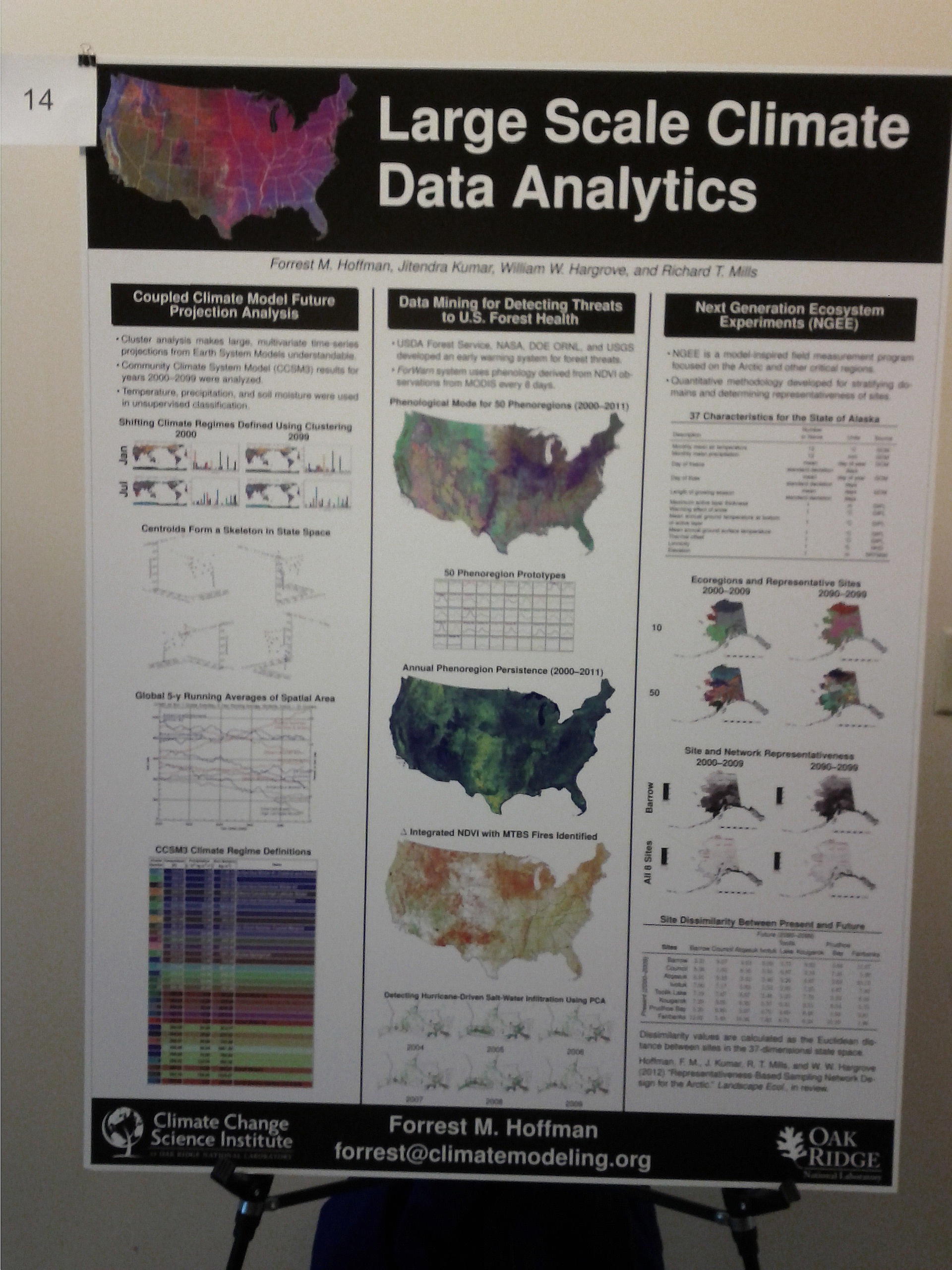
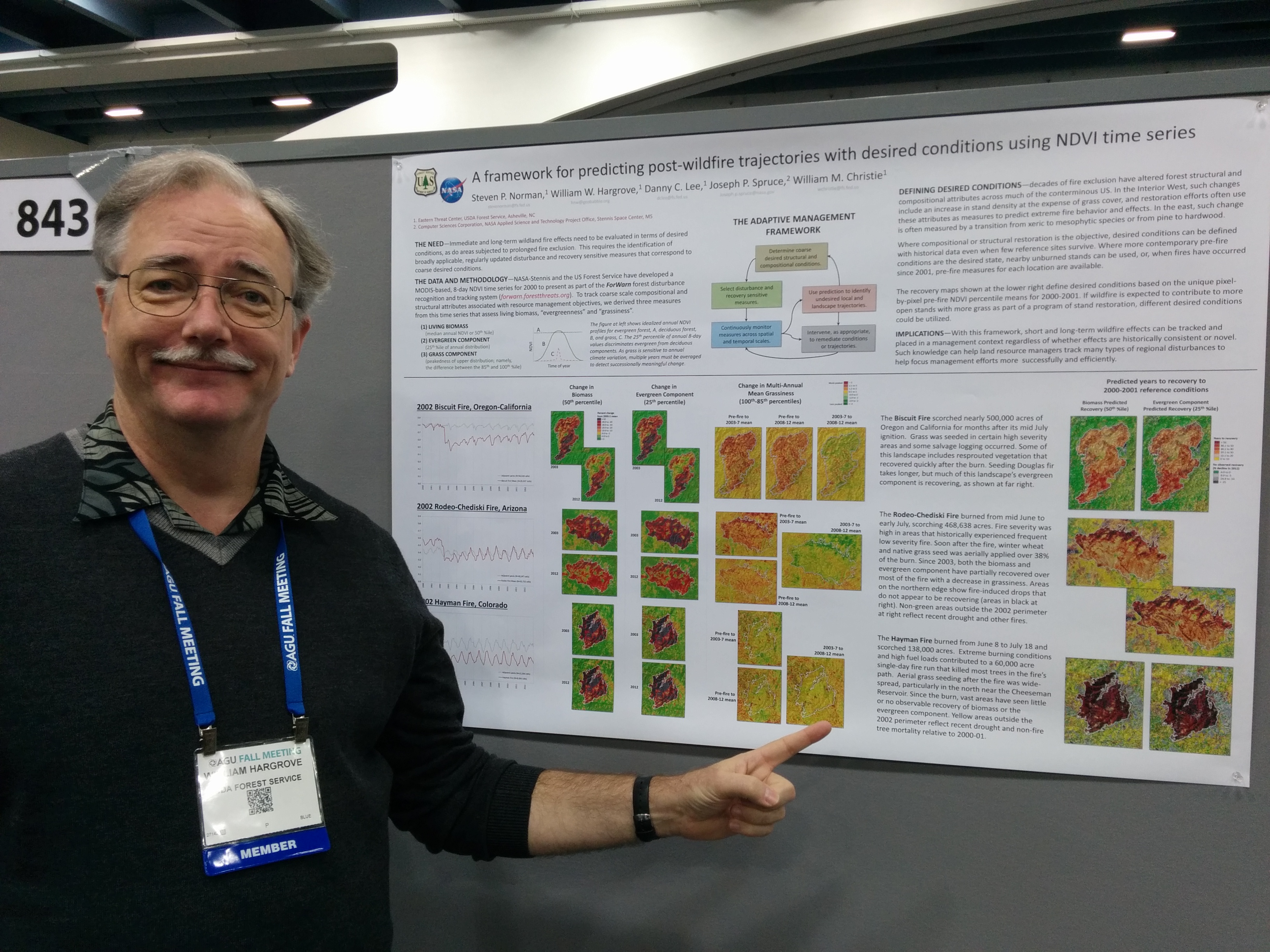
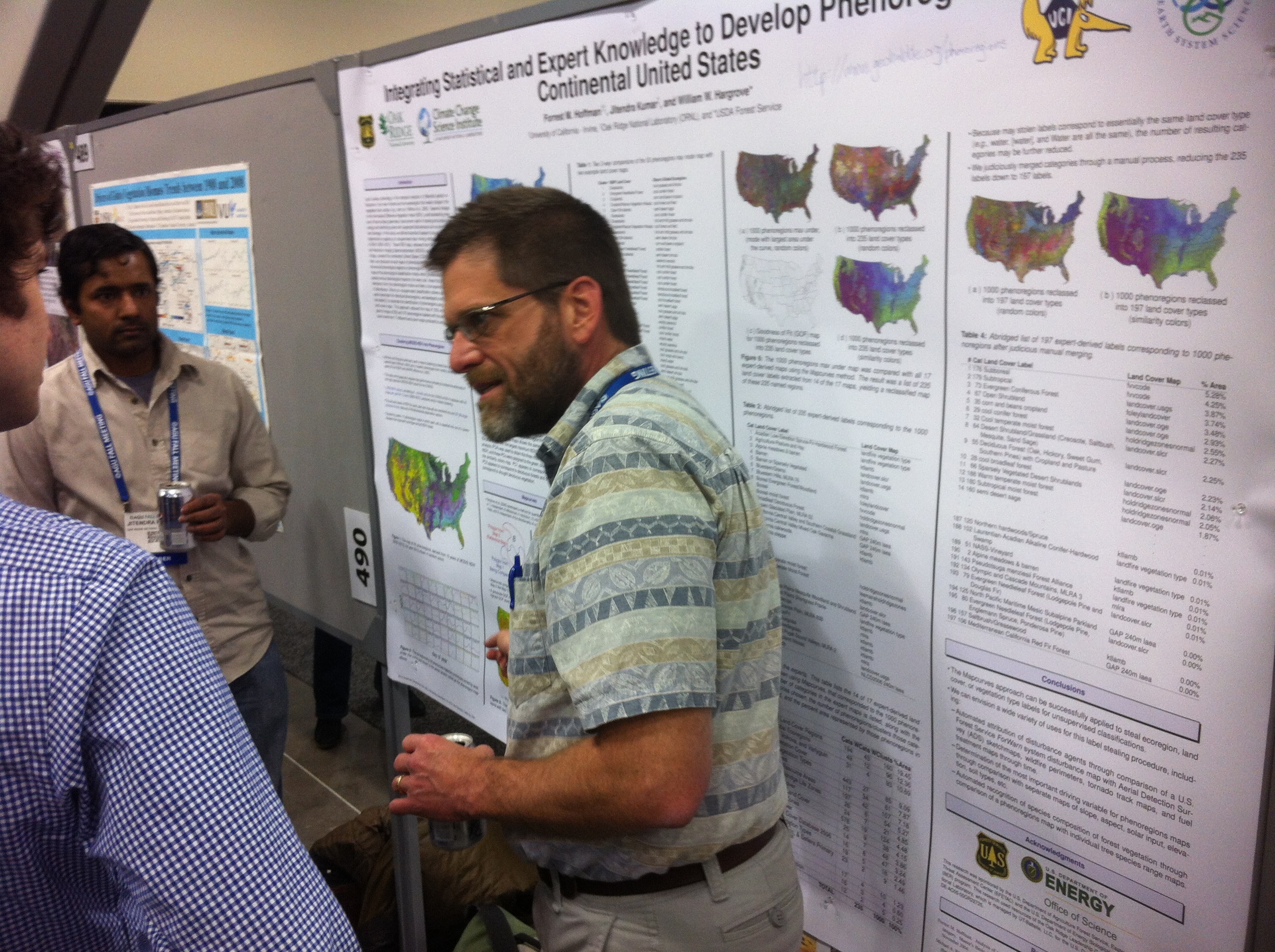
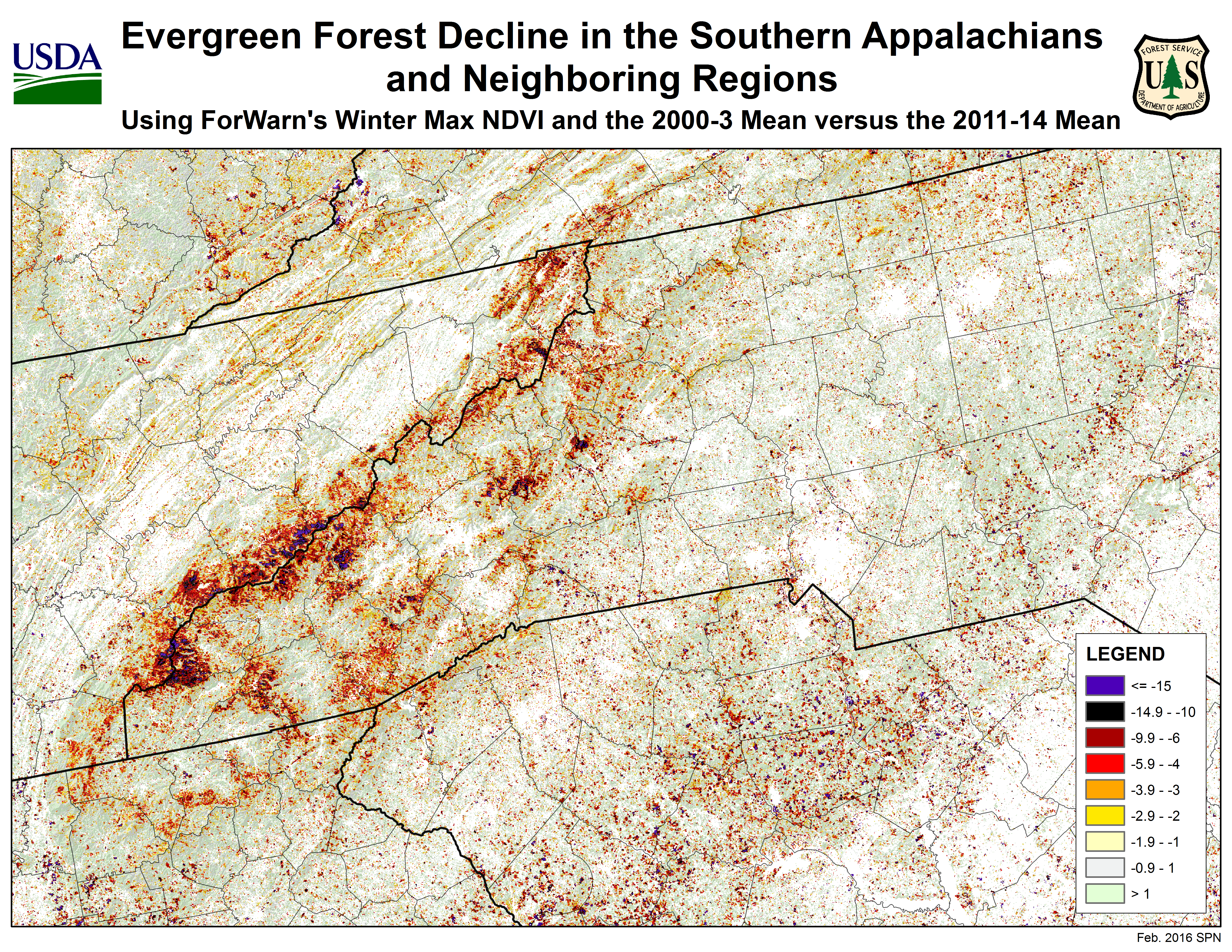