Publications
The “William W Hargrove” page on Google Scholar reports an h-index of 36 for my publications, meaning that I have 36 publications each of which have been cited by others at least 36 times. My g-index, which considers all highly cited papers, is 84, and my i10 index is 74, indicating that I have 74 publications with at least 10 citations by others. My three most-cited publications have over 500 citations each, followed by two with over 400 citations each. My nine most-cited publications have more than 250 citations each. Of those top nine, three are as first author, and two are as final author, verifying the expected transition to mentor and advisor. My median number of citations is 13. Numbers of citations for my most-highly cited publications are indicated below.
Seastedt,
T.R., D.A. Crossley, Jr., and W.W. Hargrove. 1983. The
effects of low-level consumption by canopy arthropods on the growth
and nutrient dynamics of black locust and red maple trees in the
southern Appalachians.
Ecology
64(5):1040-1048.
84
Citations.
Hargrove,
W.W., D.A. Crossley, Jr., and T.R. Seastedt. 1985. Shifts
in insect herbivory in the canopy of black locust, Robinia
pseudoacacia
L., following fertilization.
Oikos
43(3):322-328.
32
Citations.
Hargrove,
W.W. 1986. An
annotated species list of insects associated with black locust,
Robinia
pseudoacacia
L., in the southern Appalachians.
Entomological
News
97(1):36-40.
32
Citations.
Schowalter,
T.D., D.A. Crossley, Jr., and W.W. Hargrove. 1986. Herbivory
in Forested Ecosystems.
Annual
Review of Entomology
31:177-196.
412
Citations.
Hargrove,
W.W. 1987. A
video digitizer for the rapid measurement of leaf area removed by
herbivorous insects.
Technological Tools, Bulletin
of the Ecological Society of America
68(2):185.
Crossley,
D.A., Jr., C.S. Gist, W.W. Hargrove, L.S. Risley, T.D. Schowalter,
and T.R. Seastedt. 1987. Foliage
Consumption and Nutrient Dynamics in Canopy Insects.
Chapter 14, pp. 193-205 In: W.T. Swank and D.A. Crossley, Jr.
(eds.), Forest
Hydrology and Ecology at Coweeta.
Proc. symp. in Athens, Ga., Oct. 15-17, 1984. Springer-Verlag
Ecological Studies Series, Vol. 66, New York. 469 pgs.
Hargrove,
W.W., and J.R. O'Hop. 1988. A
computer algorithm to estimate leaf area removal (LAR) by insects.
Laboratory
Microcomputer 7(1):36-40.
Errata: 7(2):76.
Hargrove,
W.W., and D.A. Crossley, Jr. 1988. Video
digitizer for the rapid measurement of leaf area lost to herbivorous
insects.
Annals
of the Entomological Society of America
81(4):593-598.
27
Citations.
Hargrove,
W.W. 1988. A
photographic technique for tracking herbivory on individual leaves
through time.
Ecological
Entomology
13:359-363.
Pickering,
J., W.W. Hargrove, J.D. Dutcher, and HC Ellis. 1989. RAIN
- a novel approach to computer-aided decision making in agriculture
and forestry.
Computers and Electronics in Agriculture
4(4):275-285.
Hargrove,
W.W., and J. Pickering. 1992. Pseudoreplication:
a sine
qua non
for regional ecology.
Landscape
Ecology
6(4):251-258.
273
Citations.
This paper was identified as an early “key”
paper in Landscape Ecology
by the former Editors-in-Chief of this journal.
Turner,
M.G, W.W. Hargrove, R.H. Gardner, and W.H. Romme. 1994. Effects
of fire on landscape heterogeneity in Yellowstone National Park,
Wyoming.
Journal
of Vegetation Science
5:731-742.
545
Citations.
Tinker,
D.B., W.H. Romme, W.W. Hargrove, R.H. Gardner, and M.G. Turner.
1994. Landscape-scale
heterogeneity in lodgepole pine serotiny.
Canadian Journal of Forest Research
24:897-903.
114
Citations.
Hargrove,
W.W. 1996. Over the horizon - Perspectives on future directions in
GIS. Readers' Forum, GIS
World
9(3):28.
Hargrove,
W.W. 1996. Visualization techniques aid environmental restoration
efforts. Scientific
Computing and Automation,
October 1996:35-36.
Plotnick,
R.E., R.H. Gardner, W.W. Hargrove, K. Prestegaard, and M.
Perlmutter. 1996. Lacunarity
analysis: A general technique for the analysis of spatial patterns.
Physical
Review
E 53(5):5461-5468.
527
Citations.
The
Lacunarity
Index
is now
routinely used in medical imaging
(tumors, lung disease, osteoporosis, retinal vessels, endoscopic
ulcers, neuronal connectivity), geology
(manganese dendrites in vein quartz), genetics
( gene positions along DNA strands), engineering
(tree cracks in epoxy resin), food
science
(apple porosity, fat marbeling in cooked pork), and
remote sensing
(volumetric LiDAR, DEMs, oil slicks, river networks, urban patterns)
as well as for the landscape ecology purposes for which it was
developed. An interesting citation in the journal Food
Engineering
describes the use of the
Lacunarity Index for predicting the breakage patterns of tortilla
chips!
Lacunarity
has its own Wikipedia entry,
and a google
search
shows many lacunarity sites at hosts like MIT, NIH, and Wolfram.
Someone has produced a software package called FracLac
which calculates the Lacunarity Index for users.
Gardner,
R.H., W.W. Hargrove, M.G. Turner, and W.H. Romme. 1996. Climate
change, disturbances, and landscape dynamics.
Pages 149-172 In: B. Walker and W. Steffen (eds.). Global
Change and Terrestrial Ecosystems.
International Geosphere-Biosphere Programme Book Series - Book # 2.
Cambridge University Press, Cambridge, Great Britain. 619 pgs.
131
Citations.
Romme,
W.H., M.G. Turner, R.H. Gardner, W.W. Hargrove, G.A. Tuskan, D.G.
Despain, and R. Renkin. 1997. A
rare episode of sexual reproduction in Aspen (Populus
tremuloides
Michx.) following the 1988 Yellowstone fires.
Natural
Areas Journal
17(1):17-25.
140
Citations.
Tyler,
J.A., and W.W. Hargrove. 1997. Predicting
spatial distribution of foragers over large resource landscapes: a
modeling analysis of the Ideal Free Distribution.
Oikos
79(2):376-386.
60
Citations.
Turner,
M.G., W.H. Romme, R.H. Gardner, and W.W. Hargrove. 1997. Effects
of fire size and pattern on early succession in Yellowstone National
Park.
Ecological
Monographs
67(4):411-433.
566
Citations.
Hargrove,
W.W. 1998. Maps are not paper! Readers' Forum, GEOWorld
11(11):11.
Huff,
D.D., W.W. Hargrove, and R.L. Graham. 1999. Adaptation
of WRENSS
Fortran 77 for a GIS application for water-yield changes.
ORNL Technical Memorandum ORNL/TM-13747.
Hoffman,
F.M., and W.W. Hargrove. 1999. Cluster
computing: Linux taken to the extreme.
Linux
Magazine
1(1):56-59.
Hoffman,
F.M., and W.W. Hargrove. 1999. Parallel
computing with Linux.
Fall, 1999. Crossroads:
Association for Computing Machinery
6(1).
Hoffman,
F.M., and W.W. Hargrove. 1999. Multivariate
Geographic Clustering using a Beowulf-style parallel computer.
In: Parallel and Distributed Processing Techniques and Applications
(PDPTA '99), Vol. III, H.R. Arabina, Ed., ISBN 1-892512-11-4, CSREA
Press, pp. 1292-1298.
Zartman,
R., R.J. Luxmoore, and W.W. Hargrove. 1999. Climate. pp. 14-19
In: H. Don Scott (ed.), Water
and Chemical Transport in Soils of the Southeastern United States.
Special Report 197, Arkansas Agricultural Experiment Station,
University of Arkansas, Fayetteville, Arkansas. 388 pgs.
Hargrove,
W.W., and F.M. Hoffman. 1999. Using
multivariate clustering to characterize ecoregion borders.
Computers
in Science and Engineering
1(4):18-25.
113
Citations.
This paper was awarded Honorable
Mention by the US-International Association of Landscape Ecology
(US-IALE) for Most Outstanding Paper in Landscape Ecology in 1999.
Hoffman,
F.M., and W.W. Hargrove. 2000. High
performance computing: an introduction to parallel programming with
Beowulf.
Open
Source Developers Journal
1(1)24-31.
Stoms,
D.M., and W.W. Hargrove. 2000. Potential of
NDVI as a Baseline for Monitoring Ecostystem Functioning.
International
Journal of Remote Sensing
21(2):401-407.
85
Citations.
Mann,
L.K., A.W. King, R.A. Washington-Allen, W.W. Hargrove, V.H. Dale,
T.L. Ashwood, and L.R. Pounds. 2000. The
role of soil classification in GIS modeling of habitat pattern:
threatened calcareous ecosystems.
Ecosystems
2(6):524-538.
32
Citations.
Mahinthakumar,
G., F.M. Hoffman, W.W. Hargrove, and N.T. Karonis. 2000.
Multivariate
Geographic Clustering in a metacomputing environment using Globus.
Proceedings
of the ACM/IEEE Supercomputing '99 (SC99) Conference,
Nov. 13-15, Portland, OR.
Luxmoore,
R.J., W.W. Hargrove, M.L. Tharp, W.M. Post, M.W. Berry, K.S. Minser,
W.P. Cropper, D.W. Johnson, B. Zeide, R.L. Amateis, H.E. Burkhart,
V.C. Baldwin, Jr., and K.D. Peterson. 2000. Signal-transfer
modeling for regional assessment of forest responses to
environmental changes in the southeastern United States.
Environmental
Modeling and Assessment
5(2):125-137.
Gwo,
J.P., F.M. Hoffman, and W.W. Hargrove. 2000. Mechanistic-based
genetic algorithm search on a Beowulf cluster of Linux PCs.
Proceedings
of the High-Performance Computing 2000 (HPC 2000) Conference,
Washington, DC. http://www.pdv.cs.tu-berlin.de/HPC/hpc2000.html
Jager,
H.I., W.W. Hargrove, C.C. Brandt, A.W. King, R.J. Olson, J.M.O.
Scurlock, and K.A. Rose. 2000. Constructive
contrasts between modeled and measured climate responses over a
regional scale.
Ecosystems
3(4):396-411.
Huff,
D.D., W.W. Hargrove, M.L. Tharp, and R.L. Graham. 2000. Managing
forests for water yield: the importance of scale.
Journal
of Forestry
98(12):15-19.
Hargrove,
W.W., R.H. Gardner, M.G. Turner, W.H. Romme, and D.G. Despain.
2000. Simulating
fire patterns in heterogeneous landscapes.
Ecological
Modelling
135(2-3):243-263.
306
Citations.
King,
A.W., L.K. Mann, W.W. Hargrove, T.L. Ashwood, and V.H. Dale 2001.
Assessing the persistence of an avian population in a managed
landscape: A case study with Henslow’s Sparrow at Ft. Knox,
Kentucky. ORNL. Technical Memorandum ORNL/TM-13734.
Hargrove,
W.W. 2001. Book
review of
Terrestrial Ecoregions of North America.
Quarterly
Review of Biology
76(2):256-257.
Efroymson,
R.A., W.W. Hargrove, M.J. Peterson, D.S. Jones, W.H. Rose, L.L.
Pater, G.W. Suter II, and K.A. Reinbold. 2001. Demonstration of
the Military Ecological Risk Assessment Framework (MERAF):
Apache Longbow-Hellfire missile test at Yuma Proving Ground. ORNL
Technical Memorandum ORNL/TM-2001/211. 119 pgs.
Hargrove,
W.W., F.M. Hoffman, and T.L. Sterling. 2001. The
do-it-yourself supercomputer.
Scientific
American
256(2):72-79.
65
Citations.
Clark,
M.E., K.A. Rose, D.A. Levine, and W.W. Hargrove. 2001. Predicting
climate change effects on Appalachian trout: combining GIS and
individual-based modeling.
Ecological
Applications
11(1):161-178.
100
Citations.
Chen,
L., M.W. Berry, and W.W. Hargrove. 2001. Using
dendronal signatures for feature extraction and retrieval.
International Journal of Imaging Systems and Technology
11(4):243-253.
Hargrove,
W.W., C.C. Brandt, H.I. Jager, and R.A. McCord. 2002. A
“make-a-difference” experiment to assess the value of ARM data
in carbon cycle models. Twelfth ARM Science Team Meeting
Proceedings, St. Petersburg, Florida, April 8-12, 2002. Available
at
http://www.arm.gov/publications/proceedings/conf12/extended_abs/hargrove-ww.pdf
Luxmoore,
R.L., W.W. Hargrove, M. Lynn Tharp, W. Mac Post, M.W. Berry, K.S.
Minser, W.P. Cropper, Jr., D.W. Johnson, B. Zeide, R.L. Amateis,
H.E. Burkhart, V.C. Baldwin, Jr., and K.D. Peterson. 2002.
Addressing
multi-use issues in sustainable forest management with
signal-transfer modeling.
Forest
Ecology and Management
165:295-304.
Huff,
D.D., W.W. Hargrove, R.L. Graham, N.T. Nikolov, and M. Lynn Tharp.
2002. A
GIS/simulation framework for assessing change in water yield over
large spatial scales.
Environmental
Management
29(2):164-181.
Hargrove,
W.W., F.M. Hoffman, and P.M. Schwartz. 2002. A
Fractal Landscape Realizer for generating synthetic maps.
Conservation Ecology
6(1): 2. [online]: http://www.consecol.org/vol6/iss1/art2
58
Citations.
This paper was awarded the US-International
Association of Landscape Ecology (US-IALE) Most Outstanding Paper in
Landscape Ecology in 2004.
Hargrove,
W.W., and F.M. Hoffman. 2003. An
analytical assessment tool for predicting changes in a species
distribution map following changes in environmental conditions.
Proceedings,
GIS/EM4 Conference,
Banff, Alberta, Canada, Sept. 2-8, 2000. CD-ROM, ISBN:
0-9743307-0-1.
Hargrove,
W.W., F.M. Hoffman, and B.E. Law. 2003. New
Analysis Reveals Representativeness of the AmeriFlux
Network.
Eos
84(48):529-535.
80
Citations.
Lozar,
R.C., W.W. Hargrove, and F.M. Hoffman. 2004. "Use
of the Corridor Tool in Support of Threatened and Endangered Species
Habitat Fragmentation: Input Procedure and Initial Results."
U.S. Army Corps of Engineers, Engineer Research and Development
Center, Technical Report ERDC/CERL TR-05-23, 60 pgs.
Hargrove,
W.W., and F.M. Hoffman. 2004. A Flux Atlas for Representativeness
and Statistical Extrapolation of the AmeriFlux
Network. ORNL Technical Memorandum ORNL/TM-2004/112. Available at
http://www.geobabble.org/flux-ecoregions
Peterson,
A.T., R. Scachetti-Pereira, and W.W. Hargrove. 2004. Potential
geographic distribution of Anoplophora
glabripennis
(Coleoptera: Cerambycidae) in North America.
American Midland Naturalist 151(1):170-178.
50
Citations (acc. To BioOne).
Martinez-Meyer,
E., A. Townsend Peterson, and W.W. Hargrove. 2004. Ecological
niches as stable distributional constraints on mammal species, with
implications for Pleistocene extinctions and climate change
projections for biodiversity.
Global
Ecology and Biogeography
13:305-314.
456
Citations.
Our results suggest that hunting by early hominids likely had
little effect on the extinction of wooly mammoths.
Hargrove,
W.W., and F.M. Hoffman. 2004. The
potential of multivariate quantitative methods for delineation and
visualization of ecoregions.
Environmental
Management
34(5):S39-S60, doi: 10.1007/S00267-003-1084-0.
272
Citations.
Efroymson,
R.A, T.M. Carlsen, H.I. Jager, T. Kostova, E.A. Carr, W.W. Hargrove,
J. Kercher, and T.L. Ashwood. 2004. Toward
a framework for assessing risk to vertebrate populations from brine
and petroleum spills at exploration and production sites.
Pp. 261-285 in: Landscape
Ecology and Wildlife Habitat Evaluation: Critical Information for
Ecological Risk Assessment, Land-Use Management Activities, and
Biodiversity Enhancement Practices,
ASTM STP 1458, L. Kapustka, H. Galbraith, M. Luxon, and G.R.
Biddinger (eds.), American Society for Testing and Materials, West
Conshohocken, PA.
Efroymson,
R.A., M.J. Peterson, N.R. Giffen, M.G. Ryon, J.G. Smith, W.K. Roy,
C.J. Welsh, D.L. Druckenbrod, W.W. Hargrove, and H.D. Quarles.
2005. Investigating habitat value in support of remedial decisions:
a case study of six sites at the East Tennessee Technology Park.
Technical Report BJC/OR-2268. Bechtel Jacobs Company, Oak Ridge, TN.
White,
M.A., F.M. Hoffman, W.W. Hargrove, and R.R. Nemani. 2005. A
global framework for monitoring phenological responses to climate
change.
Geophysical
Research Letters
32(4):L04705, doi:1029/2004GL021961.
179
Citations.
Saxon,
E., B. Baker, W.W. Hargrove, F.M. Hoffman, and C. Zganjar. 2005.
Mapping
environments at risk under different global climate change
scenarios.
Ecology
Letters
8:53-60.
117
Citations.
Hoffman,
F.M., W.W. Hargrove, D.J. Erickson, III, and R. Oglesby. 2005.
Using
clustered climate regimes to analyze and compare predictions from
fully coupled general circulation models.
Earth
Interactions
9:1-27.
60
Citations.
Hargrove,
W.W., F.M. Hoffman, and P.F. Hessburg. 2005. Mapcurves:
A generalized algorithm for quantitative comparison of categorical
maps.
Journal
of Geographical Systems
8(2):187-208. DOI 10.1007/s10109-006-0025-x
88
Citations.
Hargrove,
W.W., F.M. Hoffman, and R.A. Efroymson. 2005. A
practical map-analysis tool for detecting potential dispersal
corridors.
Landscape
Ecology
20(4):361-373.
94
Citations.
Efroymson,
R. A., M. J. Peterson, N. R. Giffen, M. G. Ryon, J. G. Smith, W. K.
Roy, C. J. Welsh, D. L. Druckenbrod, W. W. Hargrove, and H. D.
Quarles. 2005. Investigating
Habitat Value in Support of Remedial Decisions: A Case Study of Six
Sites at the East Tennessee Technology Park.
Technical Report BJC/OR-2268. Bechtel Jacobs Company, Oak Ridge,
TN.
Elschlaeger,
C., J. Westervelt, H. Balbach, H. Resit Akcakaya, T. Hoctor, C.
Goodison, W.W. Hargrove, F.M. Hoffman, W. Rose, and R.C. Lozar.
2006. “Habitat
Fragmentation Handbook for Installation Planners: Status and
Options.”
US Army Corps of Engineers, Engineer Research and Development
Center, Construction Engineering Research Laboratory Technical
Report ERDC/CERL TR-06-36.187 pgs.
Fox,
D. 2007. Back to the No-Analog Future? Science 316:823-825.
Sundareshwar,
P.V, R. Murtugudde, G. Srinivasan, S. Singh, K.J. Ramesh, D.
Agarwal, D. Baldocchi, C.K. Baru, K.K. Baruah, G.R. Chowdhury, V.K.
Dadhwal, C.B.S. Dutt, J. Fuentes, P.K. Gupta, W.W. Hargrove, M.
Howard, C.S. Jha, S. Lal, W.K. Michener, A.P. Mitra, J.T. Morris,
R.R. Myneni, M. Naja, R. Nemani, S. Raha, R. Ramesh, S.K. Santhana
Vanan, M. Sharma, A. Subramaniam, R. Sukumar, R.R. Twilley, S.B.
Verma, P.R. Zimmerman. 2007. Environmental
monitoring network for India.
Science
(Policy Forum) 316:204-205.
Schimel,
D., W.W. Hargrove, F.M. Hoffman, and J. MacMahon. 2007. NEON:
A Hierarchically Designed National Ecological Network.
Frontiers
in Ecology and the Environment
5(2):59.
39
Citations.
Pittman,
J.V., E.M. Weinstock, R.J. Oglesby, D.S. Sayres, J.B. Smith, J.G.
Anderson, O.R. Cooper, S.C. Wofsy, I. Xueref, C. Gerbig, B.C. Daube,
E.C. Richard, B.A. Ridley, A.J. Weinheimer, M. Lowenstein, H-J.
Jost, J.P. Lopez, M.J. Mahoney, T.L. Thompson, W.W. Hargrove, and
F.M. Hoffman. 2007. Transport
in the subtropical lowermost stratosphere during the Cirrus Regional
Study of Tropical Anvils and Cirrus Layers – Florida Area Cirrus
Experiment.
Journal
of Geophysical Research - Atmospheres
112, D08304, DOI:10.1029/2006JD007851.
Nightingale,
J.M, N.C. Coops, R.H. Waring, and W.W. Hargrove. 2007. Comparison
of MODIS gross primary production estimates for forests across the
USA with those generated by a simple process model, 3-PGS.
Remote
Sensing of Environment
109:500-509.
68
Citations.
Williams,
C.L., W.W. Hargrove, M. Liebman, and D.E. James. 2008.
Agro-ecoregionalization
of Iowa using Multivariate Geographical Clustering.
Agriculture,
Ecosystems & Environment
123:161-171.
60
Citations.
Keller,
M., D.S. Schimel, W.W. Hargrove, and F.M. Hoffman. 2008. A
Continental Strategy for the National Ecological Observatory
Network.
Frontiers
in Ecology and the Environment
6(5):282-284.
220
Citations..
Efroymson,
R.A., M.J. Peterson, C.J. Welsh, D.L. Druckenbrod, M.G. Ryon, J.G.
Smith, W.W. Hargrove, N.R. Giffen, W.K. Roy, and H.D. Quarles.
2008. Investigating
Habitat Value to Inform Contaminant Remediation Options: Approach.
Journal
of Environmental Management
88:1436-1451.
Efroymson,
R.A., M.J. Peterson, N.R. Giffen, M.G. Ryon, J.G. Smith, W.W.
Hargrove, W.K. Roy, C.J. Welsh, D.L. Druckenbrod, and H.D. Quarles.
2008. Investigating
Habitat Value to Inform Contaminant Remediation Options: Case Study.
Journal
of Environmental Management
88:1452-1470.
Hoffman,
F.M., W.W. Hargrove, R.T. Mills, S. Mahajan, D.J. Erickson, and R.J.
Oglesby. 2008. Multivariate
Spatio-Temporal Clustering (MSTC) as a Data Mining Tool for
Environmental Applications.
M. Sànchez-Marrè, J. Béjar, J. Comas, A.E. Rizzoli, G. Guariso
(Eds.), Proceedings of the iEMSs Fourth Biennial Meeting:
International Congress on Environmental Modelling and Software
(iEMSs 2008), ISBN 978-84-7653-074-0, International Environmental
Modelling and Software Society, Barcelona, Catalonia, Spain.
33
Citations.
Peterson,
M.J., W.W. Hargrove, R.A. Efroymson. 2008. The
Apache Longbow-Hellfire Missile Test at Yuma Proving Ground:
Ecological Risk Assessment for Tracked Vehicle Movement across
Desert Pavement.
Human
and Ecological Risk Assessment: An International Journal
14(5):919-946. DOI: 10.1080/10807030802387531
Jones,
D.S., R.A. Efroymson, W.W. Hargrove, G.W. Suter II, and L.L. Pater.
2008. The
Apache Longbow-Hellfire Missile Test at Yuma Proving Ground:
Ecological Risk Assessment for Missile Firing.
Human
and Ecological Risk Assessment: An International Journal
14(5): 898-918. DOI: 10.1080/10807030802387507
Efroymson,
R.A., W.W. Hargrove, and G.W. Suter II. 2008. The
Apache Longbow-Hellfire Missile Test at Yuma Proving Ground:
Ecological Risk Assessment for Helicopter Overflight.
Human
and Ecological Risk Assessment: An International Journal
14(5): 871-897. DOI: 10.1080/10807030802387481
Serveiss,
V., D. Catanzaro, M. Fitzpatrick, W.W. Hargrove, A., Stewart, and D.
Eskew. 2008. Predicting
Future Introductions of Non-Indigenous Species to the Great Lakes
(EPA/600/R-08/066F).
National Center for Environmental Assessment (NCEA), Washington,
DC, within the Office of Research and Development (ORD) of the
Environmental Protection Agency (EPA). 138 pgs. Available from the
National Technical Information Service, Springfield, VA, and
http://www.epa.gov/ncea
Michener,
W., A. McKee, K. Bildstein, W.W. Hargrove, D. McClearn, R.
Parmenter, and M. Stromberg. 2009. Biological
Field Stations: Research Legacies and Sites for Serendipity.
BioScience
59(4):300-310. DOI: 10.1525/bio.2009.59.4.8. Reprinted In:
Topics
in BioScience: Biological Field Stations.
AIBS (eds.). 2011. University of California Press, 72 pgs. ISBN
978-0-9817130-4-5
Hargrove,
W.W., J.P. Spruce, G.E. Gasser, and F.M. Hoffman. 2009. Toward
a National Early Warning System for Forest Disturbances Using
Remotely Sensed Phenology.
Photogrammetric
Engineering & Remote Sensing
(PERS)
75(10): 1150—1156.
68
Citations.
Fitzpatrick,
M.C., and W.W. Hargrove. 2009. The
Projection of Species Distribution Models and the Problem of
Non-Analog Climate.
Biodiversity
and Conservation
18:2255-2261. DOI: 10.1007/s10531-009-9584-8
271
Citations.
Potter,
K.M., W.W. Hargrove, and F.H. Koch. 2010. Predicting
Climate Change Extirpation Risk for Central and Southern Appalachian
Forest Tree Species.
Pgs 179-189 In:
Proceedings
of the Conference on Ecology and Management of High-Elevation
Forests of the Central and Southern Appalachian Mountains.
J. Rentch and E. Heitzman, eds. Snowshoe, West Virginia, May 14-15,
2009. General Technical Report NRS-P-64. Newtown Square, PA; USDA,
Forest Service, Northern Research Station.
Hoffman,
F.M., R.T. Mills, J. Kumar, S.S. Vulli, and W.W. Hargrove. 2010.
Geospatiotemporal
Data Mining in an Early Warning System for Forest Threats in the
United States.
Pgs 170-173 In:
Proceedings
of the 2010 IEEE International Geoscience and Remote Sensing
Symposium (IGARSS 2010),
July 25-30, 2010, Honolulu, Hawaii, USA. ISBN 978-1-4244-9566-5.
DOI: 10.1109/IGARSS.2010.5653935.
Efroymson,
R.A., H.I. Jager, and W.W. Hargrove. 2010. Valuing
Wildlands.
Pgs. 157-185 In:
Environmental
Risk Assessment and Management from a Landscape Perspective.
L. Kapustka and W. Landis (Eds.). John Wiley & Sons, 396 pgs.
Baker,
B.B., H.F. Diaz, W.W. Hargrove, and F.M. Hoffman. 2010. Use
of the Koppen-Trewartha climate classification to evaluate climatic
refugia in statistically derived ecoregions for the People’s
Republic of China.
Climatic
Change
98(1-2):113-131. DOI: 10.1007/s10584-009-9622-2
63
Citations.
Spruce,
J.P., S. Sader, R.E. Ryan, J. Smoot, P. Kuper, K. Ross, D. Prados,
J. Russell, G. Gasser, R. McKellip, and W.W. Hargrove. 2011.
Assessment
of MODIS NDVI Time Series Data Products for Detecting Forest
Defoliation from Gypsy Moth Outbreaks.
Remote
Sensing of Environment
115:427-437.
116
Citations.
Mills,
R.T., F.M. Hoffman, J. Kumar, and W.W. Hargrove. 2011. Cluster
Analysis-based Approaches for Geospatiotemporal Data Mining of
Massive Data Sets for Identification of Forest Threats.
Pgs 1612–1621 In:
Proceedings
of the International Conference on Computational Science (ICCS
2011), Volume 4 of Procedia Comput. Sci.
M. Sato, S. Matsuoka, P.M. Sloot, G.D. van Albada, and J Dongarra,
(Eds). Elsevier, Amsterdam. ISSN 1877-0509.
DOI:10.1016/j.procs.2011.04.174
Kumar,
J., R.T. Mills, F.M. Hoffman, and W.W. Hargrove. 2011. Parallel
k-Means Clustering for Quantitative Ecoregion Delineation Using
Large Data Sets.
Pgs 1602–1611 In:
Proceedings
of the International Conference on Computational Science (ICCS
2011), Volume 4 of Procedia Comput. Sci. M.
Sato, S. Matsuoka, P.M. Sloot, G.D. van Albada, and J. Dongarra,
(Eds.). Elsevier, Amsterdam. ISSN 1877-0509.
DOI:10.1016/j.procs.2011.04.173
71
Citations.
Hoffman,
F.M, J.W. Larson, R.T. Mills, B.J. Brooks, A.R. Ganguly, W.W.
Hargrove, J. Huang, J. Kumar, and R.R. Vatsavi. 2011. Data
Mining in Earth System Science.
Pgs 1450-1455 In:
Proceedings
of the International Conference on Computational Science (ICCS
2011), Volume 4 of Procedia Comput. Sci.
M. Sato, S. Matsuoka, P.M. Sloot, G.D. van Albada, and J Dongarra,
(Eds). Elsevier, Amsterdam. ISSN 1877-0509.
DOI:10.1016/j.procs.2011.04.157
Hargrove,
W.W., and J.D. Westervelt. 2011. Forecasting
Climate-Induced Ecosystem Changes on Military Installations.
Engineer Research and Development Center/Construction Engineering
Research Center ERDC/CERL Technical Report TR-11-36, U.S. Army
Engineer Research and Development Center, Champaign-Urbana, IL, 133
pgs.
Hargrove,
W.W., and J.D. Westervelt. 2012. An
Application of the Pathway Analysis Through Habitat (PATH) Algorithm
as a Simple NetLogo Model.
Chapter 12 In:
Ecologist-Developed
Spatially Explicit Dynamic Landscape Models,
J. Westervelt, (Ed.) Springer-Verlag.
Potter,
K.M., and W.W. Hargrove. 2012. Determining
Suitable Locations for Seed Transfer under Climate Change: A Global
Quantitative Method.
New
Forests
43(5-6):581-599. DOI: 10.1007/s11056-012-9322-z.
49
Citations.
Mills,
R.T., J. Kumar, F.M. Hoffman, S.P. Norman, and W.W. Hargrove. 2013.
Identification
and Visualization of Dominant Patterns and Anomalies in Remotely
Sensed Vegetation Phenology Using a Parallel Tool for Principal
Components Analysis.
Procedia
Computer Science
18:2396-2405.
Hoffman,
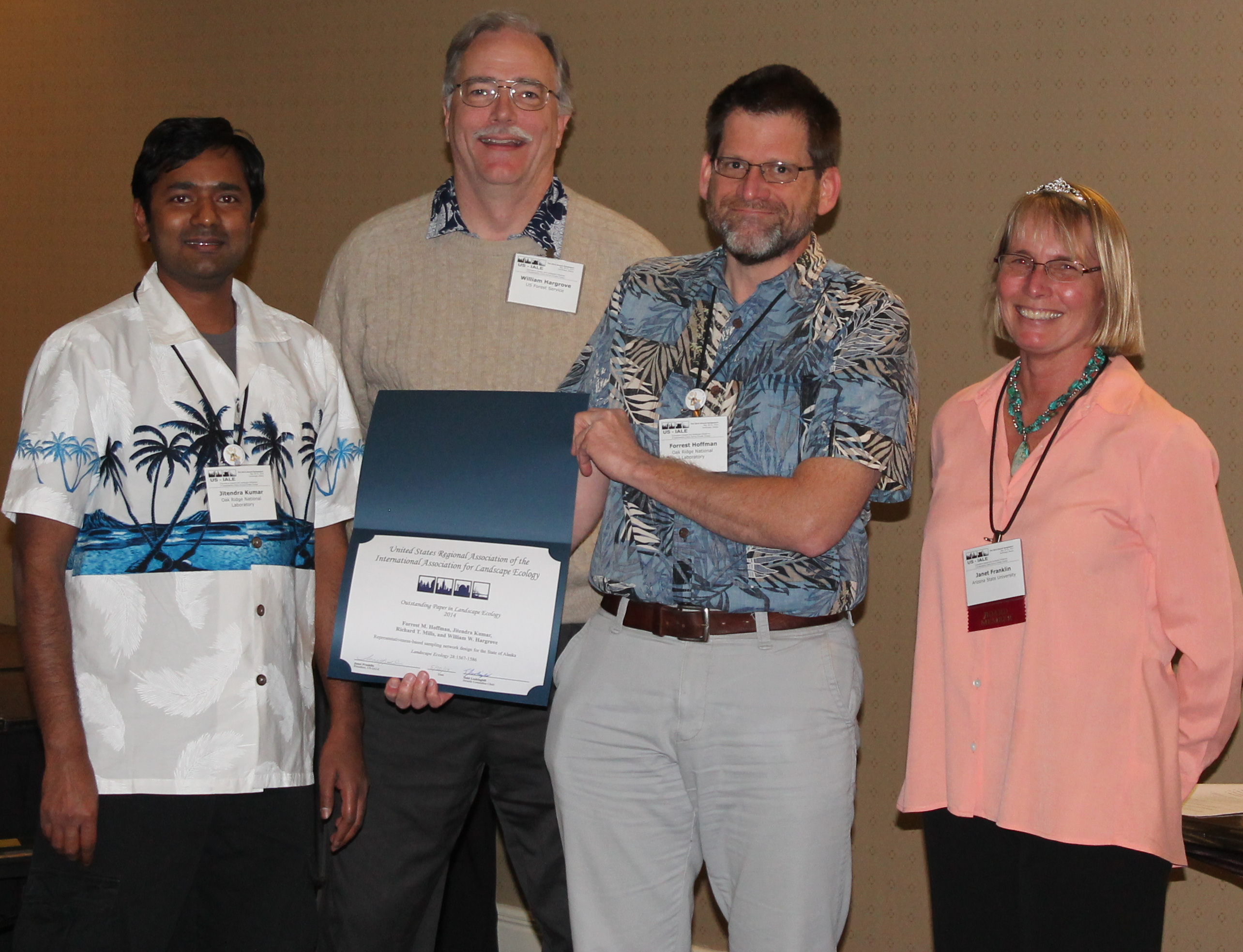
F.M., J. Kumar, R.T. Mills, and W.W. Hargrove. 2013.
Representativeness-Based
Sampling Network Design for the State of Alaska.
Landscape
Ecology
28:1567-1586. DOI 10.1007/s10980-013-9902-0.
Data
for this paper published separately as DOI:10.5440/1108686.
30
Citations.
This paper was awarded the Outstanding
Ecology Paper by the US International Association of Landscape
Ecology (US-IALE) in 2014.
Norman,
S.P., W.W. Hargrove, J.P. Spruce, W.M. Christie, and S.W. Schroeder.
2013. Highlights
of Satellite-Based Forest Change Recognition and Tracking Using the
ForWarn
System.
U.S.
Department of Agriculture Forest Service Southern Research Station
General Technical Report
SRS-180.
Asheville, NC. 30 pgs. (also available in
high-resolution,
and as a
web document)
Potter,
K.M., and W.W. Hargrove. 2013. Quantitative
Metrics for Assessing Predicted Climate Change Pressure on North
American Tree Species.
Mathematical
and Computational Forestry & Natural-Resource Sciences
5(2):151-169.
Poco,
J., A. Dasgupta, Y. Wei, W.W. Hargrove, C.R. Schwalm, R. Cook, E.
Bertini and C.T. Silva. 2014. SimilarityExplorer:
A Visual Inter-comparison Tool for Multifaceted Climate Data.
Computer
Graphics Forum :33(3):341-350.
doi: 10.1111/cgf. 12390
33
Citations.
Poco,
J., A. Dasgupta, Y. Wei, W.W. Hargrove, C.R. Schwalm, D.N.
Huntzinger, R. Cook, E. Bertini, and C.T. Silva. 2014. Visual
Reconciliation of Alternative Similarity Spaces in Climate Modeling.
Visualization
and Computer Graphics, IEEE Transactions on
20 (12):1923-1932.
doi: 10.1109/TVCG.2014.2346755
Anderson-Teixeira,
K.J., and 105 coauthors. 2015. CTFS-ForestGEO:
A Worldwide Network Monitoring Forests in an Era of Global Change.
Global
Change Biology
21(2):528-549, DOI: 10.1111/gcb.12712. Data used in
this paper are also published as DOI 10.15149/1148699.
220
Citations.
Norman,
S.P., W.W. Hargrove, J.P. Spruce, W.M. Christie. 2015. Monitoring
Forest Disturbances Across Seasons Using The ForWarn
Recognition and Tracking System.
Forest
Health Monitoring: National Status, Trends and Analysis 2013 Report.
Kevin M. Potter and Barbara L Conkling (eds.). General Technical
Report SRS-207. Asheville, NC: U.S. Department of Agriculture Forest
Service, Southern Research Station, Washington, DC. 199 pgs.
(also available at
http://www.treesearch.fs.fed.us/pubs/48361)
Jewitt,
D., B. Erasmus, P.S. Goodman, T.G. O’Connor, W.W. Hargrove, D.M.
Maddalena, and Ed T.F. Witkowski. 2015. Climate-induced
change of environmentally defined floristic domains: A conservation
based vulnerability framework.
Applied
Geography
63:33-42.
Potter,
K.M., W.W. Hargrove, and F.H. Koch. 2015. Assessing Forest Tree
Risk of Extinction and Genetic Degradation from Climate Change.
Chapter 17: 177-184 In:
Forest
Health Monitoring: National Status, Trends, and Analysis 2014.
General Technical Report SRS-209. Kevin M. Potter and Barbara L.
Conkling (Eds.). Asheville, NC: U.S. Department of Agriculture
Forest Service, Southern Research Station. 190 pgs.
Kumar,
J., J. Weiner, W. Hargrove, S. Norman, F. Hoffman, and D. Newcomb.
2015. Characterization
and Classification of Vegetation Canopy Structure and Distribution
within the Great Smoky Mountains National Park using LiDAR.
In:
Peng Cui, Jennifer Dy, Charu Aggarwal, Zhi-Hua Zhou, Alexander
Tuzhilin, Hui Xiong, and Xindong Wu, editors, Proceedings
of the 15th
Institute of Electrical and Electronics Engineers (IEEE)
International Conference on Data Mining Workshops (ICDMW 2015),
pages 1478–1485. Institute of Electrical and Electronics Engineers
(IEEE), Conference Publishing Services (CPS).
doi:10.1109/ICDMW.2015.178.
(Archived
Dataset available at the ORNL DAAC)
Norman,
S.P., F. Koch, and W.W. Hargrove. 2016. Detecting
and Monitoring Large-Scale Drought Effects on Forests: Toward an
Integrated Approach.
In:
Vose, James M.; Clark, James S.; Luce, Charles H.; Patel-Weynard,
Toral, eds. 2016 . Effects of Drought on Forests and Rangelands in
the United States: A Comprehensive Science Synthesis. USDA
Forest Service General Technical Report WO-93b.
Washington, DC: U.S. Department of Agriculture, Forest Service,
Washington Office. 289 pgs. (executive
summary)
(full
text)
doi: 10.2737/WO-GTR-93b
Equal
contributions were made from all three authors to this 30-page
review, which contains 12 Figures, 4 Tables, and over 100
references. This Drought General Technical Report received
the Chief’s Award in 2016 for “Sustaining Forests and
Grasslands.”
–
Compass
Live article here
Norman,
S.P., F. Koch, and W.W. Hargrove. 2016. A
Review of Broad-Scale Drought Monitoring of Forests: Toward an
Integrated Data Mining Approach.
Forest
Ecology and Management
380:346-358. doi: 10.1016/j.foreco.2016.06.027
(published online here,
available on TreeSearch here)
Potter,
K.M, B.S. Crane, and W.W. Hargrove. 2017. A
United States National Prioritization Framework for Tree Species
Vulnerability to Climate Change.
New
Forests
48:275-300. doi: 10.1007/s11056-017-9569-5,
Treesearch
here
Norman,
S.P., W.W. Hargrove, and W.M. Christie. 2017. Spring
and Autumn Phenological Variability Across Environmental Gradients
of Great Smoky Mountains National Park, USA.
Remote
Sensing
9(5):407-424. doi: 10.3390/rs9050407
http://www.mdpi.com/2072-4292/9/5/407/htm
Treesearch
here
Sreepathi,
S., J. Kumar, F. Hoffman, R. Mills, V. Sripathi and W.W. Hargrove.
2017. Parallel
Multivariate Spatio-Temporal Clustering of Large Ecological Data
Sets on Hybrid Supercomputers.
Institute
of Electrical and Electronics Engineers (IEEE) International
Conference on Cluster Computing, ICCC, 2017-September,
art. No. 8048938, pp. 267-277.
Brooks,
B.J., D.C. Lee, A.R. Desai, L.Y. Pomara, and W.W. Hargrove. 2016.
Quantifying
Seasonal Patterns in Disparate Environmental Variables Using the
PolarMetrics R Package.
International
Conference on Data Mining (ICDM 2017) Institute of Electrical and
Electronics Engineers (IEEE) Proceedings, DMESS 2017.
Kumar,
J., F.M. Hoffman, W.W. Hargrove, and N. Collier. 2016.
Understanding
the Representativeness of FLUXNET
for Upscaling Carbon Flux from Eddy Covariance Measurements.
Earth
Systems Science Data,
doi: 10.5194/essd-2016-36.
(preprint and reviews available online, but paper was
withdrawn
by authors due to inability to satisfy the FLUXNET2015 data use
policy authorship requirements across the entire globe,
see below)
16
citations
We imputed monthly global maps of ecosystem Gross Primary
Production for 20 years, based on upscaled flux tower measurements
from the newly released FLUXNET2015
data set. The FLUXNET2015
dataset (released in late 2016) contains global FLUXNET
measurements from member eddy-covariance flux towers located all
over the earth. We used our Generic
Imputer
(see Accomplishment #7) to produce monthly
global maps of ecosystem Gross Primary Productivity for 20 years,
producing planetwide monthly maps of GPP
from upscaled flux tower measurements. We also calculated global
representativeness of the FLUXNET network
of flux towers, showing regions which were poorly represented by the
current geographic constellation of operating FLUXNET
eddy covariance towers. Paper
was submitted to Earth System Science Data
journal for peer review. Four
reviewers posted favorable comments,
but the FLUXNET2015
Data Use Policy
required contacting
over 250 tower owners and offering authorship, not practicable.
Although reviewers lauded our leading-edge global synthesis efforts
to up-scale
local FLUXNET measurements to the global extent,
we felt that it was necessary to withdraw
the paper from publication
because we were unable
to satisfy the requirements of the FLUXNET2015 Data Use Policy.
We wrote an open
letter to the AmeriFlux Team Leaders
informing them of the problems we had encountered complying with the
FLUXNET2015 Data Use Policy,
but no single body is in charge of these planetary data. The
Co-Chief Editor of Earth
System Science Data,
Dr. David Carlson, sent all authors an email stating, “I share
your disappointment … …Consider yourselves, along with this
journal, at the leading edge of this Open Data effort.” This is
the only
time that I have ever withdrawn a scientific publication,
but it remains
available online, and continues to be cited by others.
All
results available in a Dataset at the
ORNL
DAAC, Oak Ridge, Tennessee, USA.
http://dx.doi.org/10.15486/NGT/1279968
Ergüner,
Y., J. Kumar, F.M. Hoffman, H.N. Dalfes, and W.W. Hargrove. 2018.
Mapping
Ecoregions under Climate Change: A Case Study from the Biological
“Crossroads” of Three Continents, Turkey.
Landscape
Ecology
2019 (34):35-50. Published online: 28 December 2018.
doi: 10.1007/s10980-018-0743-8.
Mills,
R.T., V. Sripathi, J. Kumar, S. Sreepathi, F.M. Hoffman, and W.W.
Hargrove. 2018. Parallel
k-means Clustering of Geospatial Data Sets Using Manycore CPU
Architectures.
Proceedings
of the 2018 IEEE International Conference on Data Mining Workshops
(ICDMW 2018).
Institute of Electrical and Electronics Engineers (IEEE), Conference
Publishing Services (CPS).
doi:10.1109/ICDMW.2018.00118
Spruce,
J.P., J.A. Hicke, W.W. Hargrove, N.E. Grulke, and A.J.H. Meddens.
2019. Use
of MODIS NDVI Products to Map Tree Mortality Levels in Forests
Affected by Mountain Pine Beetle Outbreaks.
Forests
10:811-831. doi:
10.3390/f10090811.
Brooks,
B.J., L. Pomara, D.C. Lee, and W.W. Hargrove. 2019. Tracking
Landscape Changes Using Trajectories of Clustered Polar
Coordinate-Transformed NDVI Phenoclasses. Forests
(submitted).